transit

See All Stories

Side-by-side: How Apple’s new Transit directions compare to those in Google Maps
Yesterday, at WWDC 2015, Apple introduced transit directions to its native Maps application for the first time. It’s a feature that has long been in the works, and it’s still not actually coming to consumer devices until later this year. But those who have access to the iOS 9 beta can try out the feature in select cities, including New York City, San Francisco, and others.

Transit directions aren’t new, though, and you probably know that Google has offered them in its own official Maps app for many years. But since Apple split off from using the Google-powered Maps app with iOS 6, the company has been struggling to match Google’s offerings. Here, we take a look at Google’s transit directions in comparison to Apple’s new offering…
Expand
Expanding
Close
Site default logo image

Google Maps APIs gain improved transit directions for Android developers

Google today released a set of improvements to the Google Maps APIs for developers looking to use transit directions in their Android apps. Specifically, users can now receive fare info where available and make use of the same mode and routing options as the Google Maps app.


Expand
Expanding
Close

Google breaks down how much email is encrypted during transit, launches End-to-End encryption tool

Site default logo image

Google wants you to know exactly how much email you send and receive is encrypted during transit, so today it launched a new section in its Transparency Report that does exactly that:

When you mail a letter to your friend, you hope she’ll be the only person who reads it. But a lot could happen to that letter on its way from you to her, and prying eyes might try to take a look. That’s why we send important messages in sealed envelopes, rather than on postcards… Email works in a similar way. Emails that are encrypted as they’re routed from sender to receiver are like sealed envelopes, and less vulnerable to snooping—whether by bad actors or through government surveillance—than postcards.

Google notes that Gmail has always used encryption in transit using Transport Layer Security (TLS), but that doesn’t do much if the email client on the other end isn’t doing the same.  Around 40 to 50 percent of emails between Gmail and others aren’t encrypted, according to Google, and it provided the following chart of what services are using encryption:
Expand
Expanding
Close

Google adds public Transit directions to Glass for Android users

Site default logo image

Google announced today that its latest update to Glass (XE10) includes a few new features with the most notable being the addition of Transit directions. Now, Google Glass users paired to Android device will be able to see public transit directions in addition to other related information, like when to change trains for example, on their Glass display:

We have loads of great updates every month, but there’s one we’re particularly jazz hands about — Transit. Explorers who have paired Glass to their Android phones will now have the option to see public transit directions when navigating on Glass. When you get directions and select transit, you’ll be able to see all sorts of helpful info, like where to change trains, how far you have to walk to the bus stop and how long it should take to reach your final destination.

Google has also added the “ability to tap to select links in notifications.”
Expand
Expanding
Close

Google Maps coming to iPad this summer, updated with new design, improved rating system, in-app offers, much more

Site default logo image

https://www.youtube.com/watch?v=THxJHcR1D2c&feature=player_embedded

We showed you significant updates to Google Maps which leaked early this morning, and Google just announced updates to Maps at Google I/O.

Google also announced that its Maps API is used by over 1 million active sites and accessed by 1 billion unique visitors weekly.

Maps will now feature a 5 star rating system for locations across all platforms. Users can now swipe across results in a simple, gesture user interface. Zagat reviews are now more prominent with badges and cards simplifying its appearance. These cards now include a new Offers experience with partners including Starbucks.

Google Maps for Mobile also includes improvements to rerouting in transit and explore features. Google Maps for iPad was demoed during the keynote, which we expect to see this summer, and all of the updates will come to the iPhone and Android as well.

Maps on the desktop now includes a new fly-in view for supported locations, which is like a  street view for specific landmark interiors. Public transit information on the desktop is now comparable side-by-side with standard transit and now features a new schedule view.


Expand
Expanding
Close

Your Android phone now does stop-by-stop public transit navigation

Site default logo image

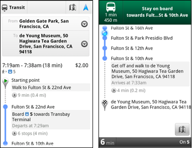
Constant checking of your location is annoying when using public transportation in a foreign city. This will become a thing of the past with the new Google Maps for Android which now features something called Transit Navigation (currently in beta). Basically, this taps Google’s vast mapping database, your phone’s GPS location and real-time public transportation data to figure out where exactly along the route you currently are. The system then alerts you on time when it’s time to hop off the buss, Google explains in a blog post:

Using your location along the route, Transit Navigation will alert you when its time to get off at your destination or to make a transfer. This is particularly helpful if you’re in a city where you don’t speak the language and can’t read the route maps or understand the announcements. 

The best bit? It runs in background so you’ll continue receiving progress reports as subtle Android notifications while checking your email or playing a game. It will even vibrate the device when it’s time to get off at next stop. Other improvements include the navigation interface with big icons and built-in picture viewer for Places pages. The new Google Maps 5.7 for Android with Transit Navigation (BETA) can be downloaded now from Android Market on smartphones that run at least Android 2.1. Transit Navigation arrives with support four hundred major cities around the world and Google will probably add more towns in the future.
[youtube=http://www.youtube.com/watch?v=1NTXkd0dguQ]

Expand
Expanding
Close