Another Maps improvement rolling out today is support for navigation in Panama, as noted by AndroidPolice. Google also confirmed the roll out by adding Panama to the list of supported countries for navigation on its website.
Google has done a lot of interesting Street View tours recently, which allow Google Maps users to explore streets, parks, historical locations, monuments, and even the inside of some buildings right from their desktop or mobile device. Today Google is adding its 56th country to Street View with the addition of Greece, a country with more than enough cultural and historical monuments to make for quite an incredible Street View experience to explore. As noted by Google, the introduction of Street View can also greatly improve the experience for tourists, businesses and others traveling through Greece:
From now on unique Greek landmarks, such as the Corfu Old Town, the White Tower in Thessaloniki and the Arch of Hadrian in the center of Athens, will be vividly represented on our computer screens… Many Greeks long have been keen for us to bring its benefits to their country, seeing Street View as a powerful tool for the promotion of a country. At a launch event in Athens, Andreas Andreadis, President of the Association of Greek Tourism Enterprises, said the new service will prove invaluable to tourists coming to Greece — and Greek businesses serving them. Visitors now will be able to check their hotel in advance and preview places they want to visit. Street View benefits everyone from the wheelchair user who can check whether a building has a ramp to the elderly who may check whether there are sufficient parking spots before leaving home. Minister of Culture and Sports Panos Panagiotopoulos welcomed Street View in Greece as nothing less than “a gift from God.”
You can check out some of the interesting locations Google captured in Greece in its own Views Gallery collection.
Google just announced a few updates rolling out to the new Google Maps desktop app today. Users will now be able to highlight StreetView imagery, user-uploaded photos, and PhotoSpheres on the map by clicking a new pegman icon in the lower right corner of their screen (pictured above). StreetView imagery will be highlighted in light blue, Photo Spheres as darker blue circles, and indoor imagery as yellow circles.
In addition, the update brings a touch of Google Earth over to the Maps desktop app with new bird’s-eye view 3D Earth Tours for all WebGL-enabled browsers.
Explore beautiful, 3D imagery of buildings and terrain for thousands of locations from above with Earth Tours available right in your browser.* Wherever you see the Earth Tour icon, you can click, sit back, and get a virtual tour from a soaring angle. Dive into Boston or circle the Alps.
Google is also rolling out a new preview UI for directions. Now, when viewing individual steps for directions you’ll see StreetView imagery on each step where available, allowing you to get a better sense of your surroundings for an upcoming turn or exit. Google also notes that it has integrated real time traffic incident reports from its Waze acquisition like it recently did in its mobile Google Maps apps.
The new Google Maps desktop app is rolling out to all that opted into the new Google Maps preview today and to everyone else in teh coming weeks. Google also just released a video preview for the new Google Maps desktop experience that shows off some of the new features in today’s update: Expand Expanding Close
Google’s Streetview has taken us to some pretty interesting places lately. We’ve had the world’s tallest skyscraper, the Eiffel Tower, a Bond villain’s lair and a trek up to the top of Mount Fuji, but this is the first time we’ve been able to visit other dimensions – with a wander around inside Dr Who’s TARDIS.
Start here, outside London’s Earls Court tube station, then follow the instructions below the fold … Expand Expanding Close
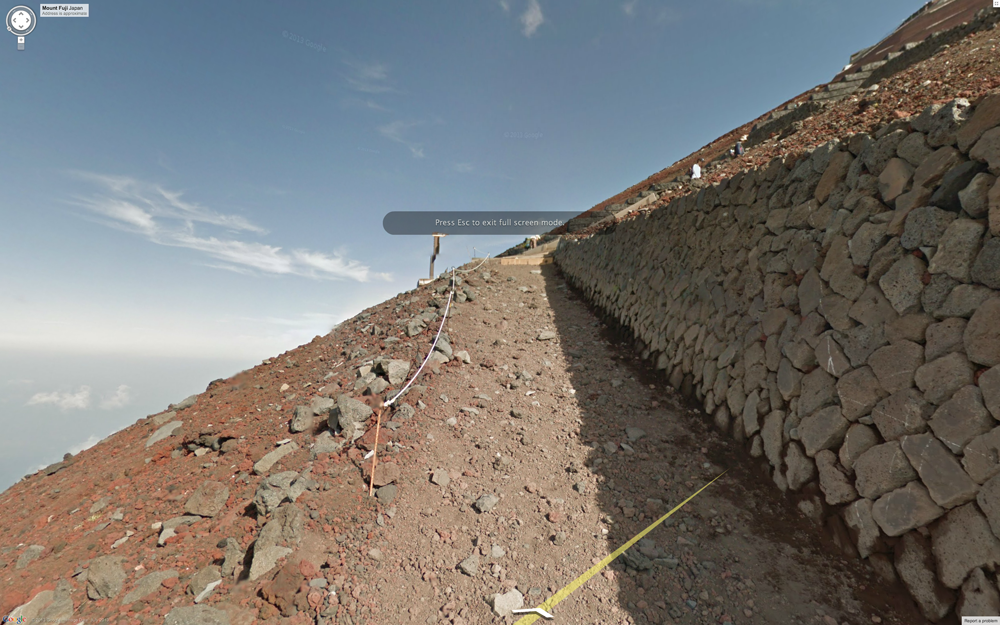
This newly elevated status from UNESCO is likely to send a record number of climbers to Mt. Fuji during the summer’s official climbing season. To help them prepare for the grueling trek over loose igneous rock, we hauled the Street View Trekker up all 3,776 meters of Mt. Fuji, and today we are launching the resulting 360-degree panoramic imagery. The Street View collection covers the highly popular Yoshida trail that takes hikers up the mountain, the full walk around the crater at the top, and the quick zigzag descent.
In all, the virtual tour contains a staggering 14,000 panos. The blog also links to a bunch of other UNESCO World Heritage Sites in Japan.
Google updated its Google Earth app for iOS and Android today with a few new features including a revamped interface that includes the left side panel it has been bringing to lots of its mobile apps.
Also new in version 7.1.1 of Earth is Google’s Street View feature, as well as improved directions and search with the ability to “visualize transit, walk, bike and drive directions in 3D while update search result list will let you browse search results quickly.” Google also announced that it is now making Google Earth available in over 100 countries worldwide:
Also with this release, we’re making Google Earth for mobile available in more than 100 countries worldwide, so you can start their virtual journey in Google Earth from almost anywhere on Earth. To unleash your inner explorer, check out your local Google Play store or iTunes to download the latest version of Earth for Android and iOS.
Google not only escaped criminal prosecution in Germany after its Street View cars were found to be capturing private wifi traffic, but it has now pretty much walked away scott-free as the Commissioner for Data Protection and Freedom of Information fined it just €145,000 ($190,000).
The pointless fine (reported by Engadget) could probably be paid with the change found buried in the seats of the Streetview cars … Expand Expanding Close
While still taking its sweet time building a Maps app for iOS, Google is making sure to take care of its own business today by launching the biggest update ever for Street View.
Street View is a five-year-old feature in Google Maps and Google Earth that provides panoramic views of many streets in the world, and its latest update adds over 250,000 miles of roads from around the globe. Google’s Street View team elaborated on the service’s expansion in a post on the official Lat Long blog:
We’re increasing Street View coverage in Macau, Singapore, Sweden, the U.S., Thailand, Taiwan, Italy, Great Britain, Denmark, Norway and Canada. And we’re launching special collections in South Africa, Japan, Spain, France, Brazil and Mexico, among others.
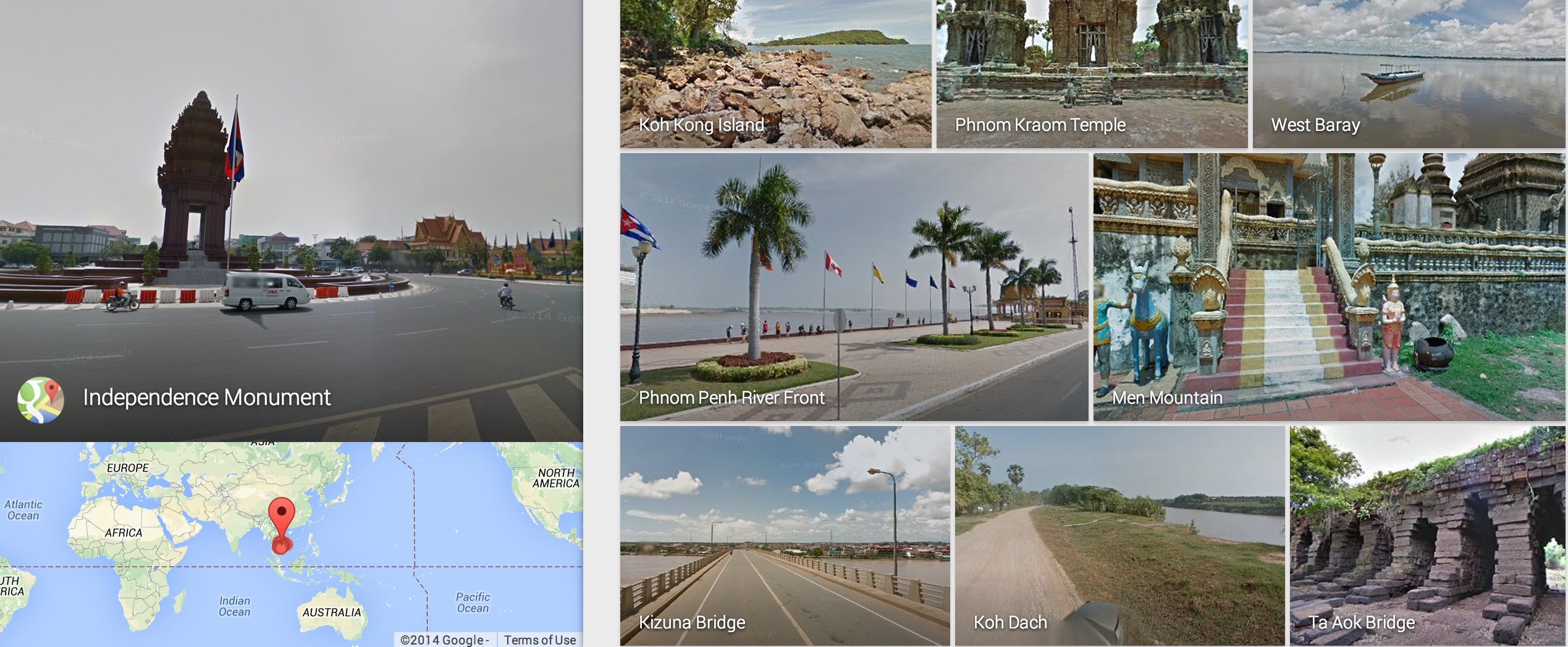
Every hear of Cambridge Bay? It is not in the United Kingdom, as one might think, but rather the Kitikmeot Region of Nunavut in Canada’s Arctic and Google is trying to put it on the map.
There are 4,000 years’ worth of stories waiting to be told on this map. Today, we’re setting out on an ambitious mission to tell some of those stories and to build the most comprehensive map of the region to date. It is the furthest north the Google Maps Street View team has traveled in Canada, and our first visit to Nunavut. Using the tools of 21st century cartography, we’re empowering a community and putting Cambridge Bay on the proverbial map of tomorrow.
Google further revealed a local nonprofit group, Nunavut Tunngavik, is helping to map the hamlet in both English and Inuktitut, which is one of Nunavut’s official languages, while the Internet giant pedals around with a tripod and the Street View trike to collect imagery.
“This is a place with a vast amount of local knowledge and a rich history. By putting these tools in the hands of our people, we will tell Nunavut’s story to the world,” said Nunavut Tunngavik’s Chris Kalluk, who’s organization helped plot the remnants of an ancient Dorset stone longhouse that pre-dates Inuit culture.
Get more mapping details and images at the Google blog.
My, how time flies. It has been nearly seven years since Hurricane Katrina wreaked havoc on Louisiana, but a fresh look through Google’s Street View imagery shows New Orleans and the surrounding area has come a long way.
“The Street View imagery in Google Maps, which has just been updated today, more accurately reflects the major construction and renewal that’s underway,” announced New Orleans Mayor Mitch Landrieu on the official Google Lat Long blog.
[youtube=http://www.youtube.com/watch?v=6BnUoTyATLo&feature=player_embedded] As a special celebration for the 50th anniversary of NASA’s Kennedy Space Center, Google announced today that it added a new collection of Street View imagery that allows users to explore the area through 6,000 panoramic views of the complex. To accomplish the task, Google teamed with NASA to capture the special set of imagery. It will allow you to explore outside the facility and areas like the “top of the enormous launch pad.” Some of the locations you can now explore in Street View include the space shuttle launch pad, Launch Firing Room #4, Vehicle Assembly Building (taller than the Statue of Liberty), and the space shuttle’s main engines.
For fifty years, NASA’s Kennedy Space Center in Florida has been the launch point for a generation of space technology and exploration. Countless enthusiasts (including this one) grew up longing to see a space shuttle up close and walk in the paths of astronauts. Today, a collaboration between NASA and Street View is enabling people around the world to take a trip to the doorway to outer space, and see Kennedy as it transitions into a multipurpose launch complex for the next 50 years of space innovation… We’d like to thank NASA for making this project possible and giving all of us the chance to digitally walk in the shoes of all of the pioneering astronauts, scientists, engineers and technicians that made our space dreams possible.
If you want to see Google’s largest special collection of Street View imagery for the NASA Kennedy Space Center, go to maps.google.com/nasa now. Expand Expanding Close
Google just revealed a backpack-like Street View capture device called “Trekker” that snaps images in areas impossible to navigate by vehicle (above).
“It’s 40 pounds and includes two batteries that’ll last you all day. It’s Android-powered…. We intend to take it to National Parks, the Grand Canyon, castles, etc.,”explained Google’s Engineering Director of Street View Luc Vincent at the “Next Dimension” Google Maps event in San Francisco.
The director further said street level data “could be” useful for users, and then he showed off an original Street View van (below). It is a Chevy Astro and definitely does not compare to newer Street View cars.
It is worth mentioning that Google announced it drove over 5 million unique miles to collect 20 petabytes of imagery for Street View.