
During its “Search On” event this afternoon, Google announced new changes and updates in an effort to better track climate change. Google Maps is adding a new “Fire” layer to its apps as Google’s “Tree Canopy” tool is set for expansion.
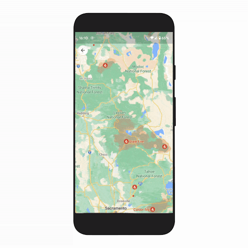
Starting on Android this week and on iOS next month, Google Maps will show active wildfires as a top-level layer in the app, an expansion of efforts that started last year. That means users will be able to see wildfires in their area using the layer right alongside traffic, satellite, and transit layers.
Google has said (via ArsTechnica) that this new layer will aggregate wildfire information from government agencies. In the US, this includes information from the National Interagency Fire Center. In Australia, Google hopes to add information from agencies “in the coming months.” The layer will also surface information such as emergency phone numbers and websites as well as evacuation information. Other details, such as containment and how many acres have burned, will be added to these pages as they are available as well.
The wildfires layer will start to roll out globally this week on Android, with iOS and desktop coming in October, and will display most major fires that cause significant evacuations. In the U.S., the layer will expand to include more fires thanks to data from the National Interagency Fire Center (NIFC). We plan to expand this level of detail to more countries, starting with Australia, in the coming months.

Beyond the new Fire layer in Maps, Google is also expanding its Tree Canopy tool. Currently available in 15 cities, Google will expand the tool to 100 cities around the world. The tool shows the coverage of trees in urban areas to show how these areas are affected by heat and poor air quality. Google wants officials in these citiies to use the data to plant trees in the right areas, and says that LA, Chicago, Austin, Louisville, and Miami are currently using the data.
Cities around the world have told us that it can be difficult to set concrete climate action goals when they don’t have access to reliable, trusted information. That’s why in 2022, we’ll expand the Environmental Insights Explorer (EIE) Tree Canopy tool from 15 U.S. cities to over 100 new cities around the globe in places like Guadalajara, London, Sydney and Toronto.
FTC: We use income earning auto affiliate links. More.
Comments