Google Maps

Google has acquired Jetpac, a city guide application for iPhone, the app’s developers announced today (via The Next Web). The free app (and others by the Jetpac team) will be removed from the App Store in the coming days, and the service that powers it will be shut down on September 15th.
Google hasn’t said exactly what it plans to do with the company’s technology, which automatically scans users’ photos to detect local points of interest like coffee shops or “hipster hangouts.” The service featuerd data for over 6,000 cities, according to the App Store description. It seems logical, however, that Google would attempt to integrate these features with Google Maps or a location-based Google Now feature.
You can grab the Jetpac app for free on the iTunes Store, though it won’t be very useful beyond its mid-September shutdown.

Google’s Street View has been around for a little more than seven years and while Mountain View’s touring software has made a lot of progress since its launch, there’s still plenty of room for improvement. Aware of this, a hearing aid manufacturer named Amplifon is looking to update Street View’s silent movie feel by introducing a new concept called “Sounds of Street View.”
Google announced today that it’s completely turning down Google Maps API for Flash on September 2nd. This decision follows suit with the company’s initial depreciation period, which started almost three years ago. Developers now have three weeks to migrate their outdated applications to JavaScript Maps API v3 in order for them to remain relevant.


Google announced today that it’s added Street View imagery for a long list of new university campuses in Google Maps. The new schools, which include campuses across the U.S. and Canada, are available to explore starting today.
Google notes that these new additions add to the hundreds of school campuses you can already explore in Google Maps. It highlighted a few of the new campuses rolling out today in its announcement including Georgetown University, University of Miami, and the University of Regina in Canada.
To see if a Street View tour of your dream school is available, search for a particular university on Google Maps and click on Pegman to enter the Street View imagery. Visit our Street View gallery for global highlights and other popular universities around the world.

Google quietly launched an interesting new feature within Google Maps yesterday: the ability to explore both Mars and the Moon. As you may know, you’ve been able to do this with the desktop Google Earth app for quite some time — but this is the first time it has come to the web via the ubiquitous mapping platform. To access the new feature, head over to Maps, click the “Earth” button in the bottom-right, zoom all the way out, and wait for the ‘Moon’ and ‘Mars’ options to appear as seen in the screenshot above. Alternatively, you can just click these links: goo.gl/OopkP0 (Mars), and goo.gl/CoVGQ9 (Moon).
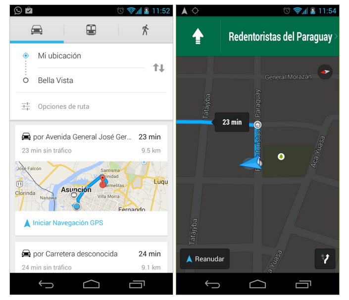
A beta for Google Maps navigation is now available in El Salvador, Libya, Nicaragua, Paraguay, and Tunisia. While some countries may take this feature for granted, other territories don’t widely have access to this type of free software. For example, residents of North Korea have combined their efforts to produce a community developed version of Google Maps.

Google announced today the availability of 76 historical sites in India that can be viewed from Google Maps or through the Google Cultural Institute site. These 360-degree photos will let you take a tour of the Kangra Fort without having to pack a single bag. Thanks to support from the Archaeological Survey of India (ASI), along with previous efforts, Google’s imagery of historic shots of India has surpassed 100 pictures, with locations like the Taj Mahal and Humayun’s Tomb already available to view.

Google announced on Thursday that, starting today, all Google Maps Engine Pro users will now have access to the Maps Coordinate suite of productivity tools. Google is also opening the Coordinate app for Android to anyone with a Google account, whereas you previously needed to be a Google Apps user.
Expand
Expanding
Close
Google has announced that it’s bringing more ads to Google Maps on both the desktop and mobile by integrating local ads into the new list view for search results it rolled out recently. That means that when you search for things like restaurants, hotels, and other points of interest, you’ll see ads appear at the top of the search results in addition to overlaid on the map itself (as pictured above).
Expand
Expanding
Close
Google recently updated its Views platform with comments and +1 support. This lets people reach out to photographers about their photo spheres and opens up conversations for subjects like technique and travel. Packed with awesome images, some of the community produced photo spheres have already racked up millions of views, according to Google Maps product manager, Evan Rapoport.
Just in time for Google’s Android One rollout in India and other developing nations, Google is opening up Maps to millions of native speakers in India today with localized Maps on both the web and Android that show Hindi for the first time alongside English:
Expand
Expanding
Close

Google this afternoon updated its Maps app on Android to version 8.2 with a plethora of new features, enhancements, and changes. The biggest changes come to the biking routes that Maps offers. With this update, biking routes now show elevation, including the ability to compare the elevations for various routes. This, of course, means that you can now easily tell which bike routes will be the easiest on your legs. This feature is listed as beta for now, though.

London may be an expensive tourist destination, but Google will soon offer the next best thing to hopping on a plane: complete 3D imagery of the entire city. The London Evening Standard reports that every building in London will soon be included.
A Google Maps spokesman said: “Using 45-degree aerial imagery, we’re able to recreate entire metropolitan areas in 3D. This means every building, not just the famous landmarks, the terrain, and any surrounding landscape of trees are included to provide a much more accurate and realistic experience of the city” …
In a blog post on its official enterprise blog today, Google announced that it is opening up its collection of Google Earth data to businesses. Businesses and governmental organizations will now have the ability to purchase imagery collected by Google and use them for whatever they need. Since it launched 9 years ago, Google Earth has built up an incredible collection of image data, and it only makes sense for the company to continue to profit off of it.
New Scientist reports that Google is now using Street View cars to detect methane leaks from corroded pipes, landfill sites and other sources.
Sensors strapped to the top of the cars have mapped hundreds of methane leaks around Boston, New York’s Staten Island and Indianapolis […]
Methane leaks are a triple threat: they can cause explosions, accelerate the growth of global warming and waste money. A study last year found that US methane emissions are 1.5 to 1.7 times higher than current estimates, a discrepancy that has been attributed to hard-to-detect leaks …
We’ve all heard about the Loch Ness Monster, which according to legend is a cryptic lake monster that roams through the waters of the Scottish Highlands. While the creature has never been proven to exist, it appears that the Google Maps team has decided to name a lake in Scotland after it in what amounts to a strange mistake.
Expand
Expanding
Close
When MythBusters co-host Adam Savage isn’t trying to debunk urban legends, he’s most likely working on projects at his workshop in San Francisco, which the TV personality refers to as “the cave.” Aside from its raw industrial motif, Savage’s setup is loaded with a vast collection of costumes and gadgets that rival a big budget movie studio. Although his shop isn’t exactly open for public tours, Google’s Business View is offering the next best thing.
Google recently updated its desktop version of Maps with a new feature that lets users measure the distance between two or more points on the map. To toggle this option, right-click on a starting point on the map and select “Measure distance,” and then choose a destination to see the distance between the two points.
Amidst the ‘controversy’ of the recently-introduced ‘right to be forgotten‘ on Google, the Independent reports that celebrities and other public figures are asking Google to blur the Street View images of their homes. Musicians Paul McCartney, Jimmy Page, Lily Allen and Katherine Jenkins are amongst those named as having taken advantage of the Google tool to request this. Google’s Street View privacy page says that in addition to the blurring it already does automatically (including faces, some street numbers and some homes), additional blurring is done on request.
We provide easily accessible tools allowing users to request further blurring of any image that features the user, their family, their car or their home. In addition to the automatic blurring of faces and license plates, we will blur the entire car, house, or person when a user makes this request for additional blurring.
(via Gizmodo)
Google released another web-based game today called Smarty Pins that will most likely distract you from other things that you should be doing. Powered by Google Maps, this quiz game tests your knowledge about historical and current events by asking you location-based questions. To answer a question, players drop a pin on the correct location and instead of earning points, you’ll rack up miles to keep the game going. As a slight help, the pin starts out in the same region as the correct answer, so there’s no need to move too far across the map.
Google this morning rolled out an update to the Maps app on Android with a feature that will certainly make Google I/O 2014 attendees happy. Bumping the app to version 8.1.1, the update resolves the issues surrounding Android Wear’s compatibility with Google Maps.
Many Google I/O attendees noted that the Maps integration with the new Android Wear devices was entirely nonexistent, despite Google’s on-stage demos. Today’s update, however, adds integration between Wear and Maps like Google showed us during its keynote. With Maps on a smartwatch, you can search for a location and start navigation directly from your wrist. The watch, of course, still communicates with your phone for the data.
Now that Google has officially released the full Android Wear SDK, we expect to see a lot of apps updated with Android Wear support over the coming days and weeks. You can download the Google Maps update on the Play Store now.
Google has done a lot of interesting Street View tours recently, which allow Google Maps users to explore streets, parks, historical locations, monuments, and even the inside of some buildings right from their desktop or mobile device. Today Google is adding its 56th country to Street View with the addition of Greece, a country with more than enough cultural and historical monuments to make for quite an incredible Street View experience to explore. As noted by Google, the introduction of Street View can also greatly improve the experience for tourists, businesses and others traveling through Greece:
From now on unique Greek landmarks, such as the Corfu Old Town, the White Tower in Thessaloniki and the Arch of Hadrian in the center of Athens, will be vividly represented on our computer screens… Many Greeks long have been keen for us to bring its benefits to their country, seeing Street View as a powerful tool for the promotion of a country. At a launch event in Athens, Andreas Andreadis, President of the Association of Greek Tourism Enterprises, said the new service will prove invaluable to tourists coming to Greece — and Greek businesses serving them. Visitors now will be able to check their hotel in advance and preview places they want to visit. Street View benefits everyone from the wheelchair user who can check whether a building has a ramp to the elderly who may check whether there are sufficient parking spots before leaving home. Minister of Culture and Sports Panos Panagiotopoulos welcomed Street View in Greece as nothing less than “a gift from God.”
You can check out some of the interesting locations Google captured in Greece in its own Views Gallery collection.
[youtube=http://www.youtube.com/watch?v=5t4m9lII8mk&list=UUS-dIYJRJz01BwmqZBaqVHA]
Following the official Gmail app passing the billion download mark last month, Google Maps has now passed that very same milestone (via Android Police). The app, very obviously one of Google’s most-used services, is widely cherished by both iOS and Android users to get them where they need to go (especially when iOS maps doesn’t quite do the trick).
Notably, this billion downloads for the app means that yes, 1 billion separate Play Store accounts have downloaded the app — it’s not counting repeat downloads on one account. What’s even more crazy? The app passed 50 million downloads in 2011 (and was the first to do so). In just 3 short years, Maps took off exponentially to see another 950 million downloads on separate accounts. That number doesn’t even count iOS downloads.