
Google Maps

See All Stories

Google iOS app updated w/ Material Design, Street View integration, more

Site default logo image

Google is rolling out a completely redesigned version of its iPhone and iPad app with its Material Design look and feel right down to the app icon.

The latest version of the search app now presents a bottom navigation bar (which can slide out of view) that presents a persistent Google button for searching for new information. The navigation bar also offers a button for quickly accessing recent search pages, something that feels similar to multitasking between apps on Android.

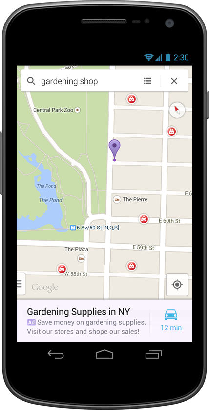
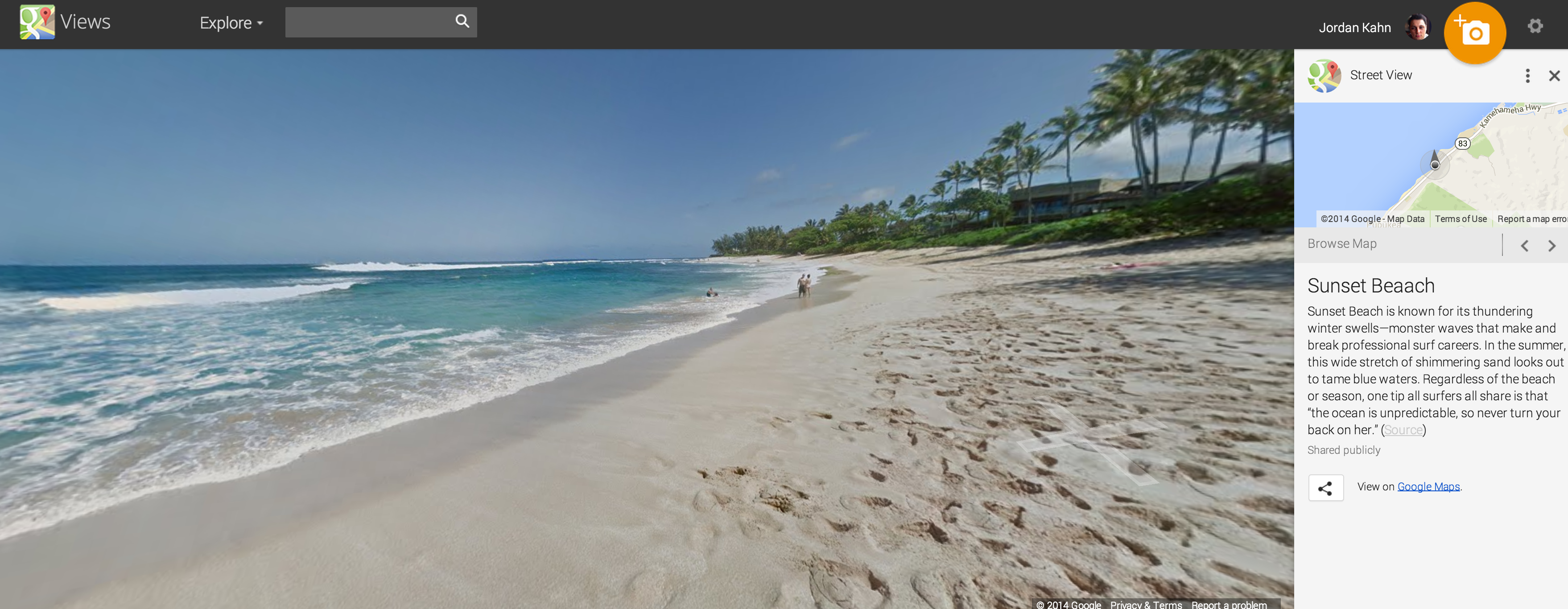
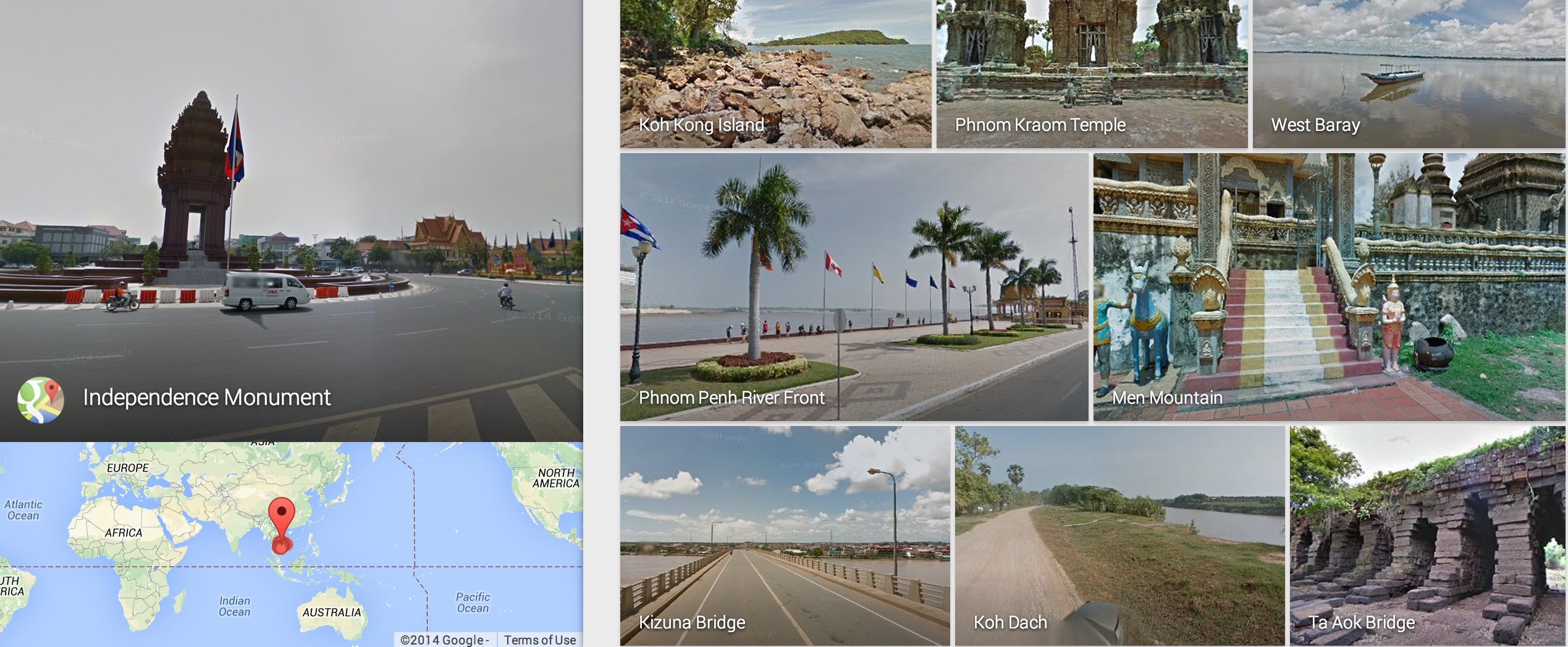
Also notable as part of the redesign is the optimization searching for photos has received. In the latest version of Google’s iOS app, image results now take on a full-screen, mosaic look for presenting larger results. The update also packs in deep Google Maps integration for location searches including support for Google Street View right in the app for iPhone users. You can read the full change log below:
Expand
Expanding
Close

Google Earth and Maps get new 3D imagery for San Francisco, New York City

Google has today updated the 3D imagery in both Google Earth and Google Maps, taking advantage of newer cameras to provide much better accuracy and a more realism in select United States cities. The newer imagery can be seen on the left in the image above, where it’s obvious that the San Francisco City Hall building’s contours and architecture now have much greater clarity.

Google says that the first two cities to get this treatment are the San Francisco Bay Area and New York City, New York. But while these two cities are the first to see the update, they definitely won’t be the last. More cities will be getting the new imagery throughout 2015, according to Google.

To give you another look at the new imagery, here’s the new view of the Statue of Liberty (left is new, right is old):

As you can see below, there’s also new imagery that only recently became possible. The new 3D view includes the relatively new Six World Trade Center in New York, and there’s also new imagery of the Bay Bridge:

Google Santa Tracker is back with an educational twist

Site default logo image

Google and Santa have a lot in common. They know when you are sleeping/awake. They also give you cool stuff but also freak you out a little bit sometimes.

Well, Google also keeps tabs on Santa and for the umpteenth consecutive year Google is following Santa on his round the world trip from the North Pole on Christmas.  This year’s tracker has some fun games to play every day but this year you might actually learn a thing or 2:

This year, you’ll find an edu touch — new geography games let you explore local holiday traditions, while a new coding project teaches basic JavaScript as you help Santa and the reindeer navigate the map. Learn how to say “Santa” in different languages, and connect with nonprofits around the world.

Of course, fan favorites are making a return this year — you can send a call from Santa to your friends and family, display Santa’s journey on the TV screen with Chromecast, and play gumdrop and reindeer racing games. You’ll be able to play each game on desktop, mobile web, or on the Santa Tracker Android app.

Jump on board with the Android app, Chrome extension or website or follow Google Maps on Google+, Facebook and Twitter in the countdown #tracksanta.


Expand
Expanding
Close

Google introduces ability to embed Street View images and Photospheres

Site default logo image

[googlemaps https://www.google.com/maps/embed?pb=!1m0!4v1416448266011!6m8!1m7!1s9WgYUb5quXDjqqFd3DWI6A!2m2!1d46.41438376976309!2d10.01394735785013!3f210!4f10!5f0.7820865974627469&w=704&h=400]

Google, in a post on the Geo Developers Blog, today announced the ability for website owners to embed Street View panoramas and Photospheres within their site using an HTML snippet. Google launched this feature for Maps last year, but only today did it add support for Street View and public Photospheres.

Today, we added the ability to easily embed the Street View and Photo Sphere images you find in Google Maps and we’re also enabling the same capabilities programmatically in the Google Maps Embed API. These embeds use the new imagery viewer technology that powers Street View in the new Google Maps.


Expand
Expanding
Close

Google Maps honors Veterans Day with Street View tours of U.S. historical places

With today marking Veterans Day, Remembrance Day and Armistice Day in the United States and countries that belong to the Commonwealth of Nations, along with several other regions worldwide, Google announced this morning that users can now tour some significant U.S. historical places in Street View on Google Maps.
Expand
Expanding
Close

Google Maps for Android updated with a fresh new Material Design layout, Uber and OpenTable integration

Site default logo image

Google announced a new update for its Google Maps apps for Android and iOS today that adds a fresh new Material Design layout focusing on bright colors and real world surfaces and shadows. The software’s refreshed interface is set to roll out over the next few days, with new features like dinner reservations from OpenTable (US only) and enhanced information cards with photos and reviews of popular attractions near your location.


Expand
Expanding
Close

Site default logo image

Canadian woman successfully sues Google for showing her cleavage on Street View

One from The Dept of You Couldn’t Make It Up. A court has awarded a Canadian woman $2,250 in damages against Google for showing her cleavage in a Street View image, reports Le Journal de Montréal (via GigiOM).

Photographed by a Street View car in 2009 while sitting on her stoop leaning forward in a low-cut top, the judge ruled that Mario Pia Grillo suffered shock and embarrassment when co-workers spotted the image.

Google had automatically blurred her face, but the court accepted her argument that she was identifiable from the fact she was sitting outside her own home. Google subsequently blurred her entire home.

Quebec’s legal system is modelled on that of some European countries, like France, where you retain a right to privacy against intrusive photography even in a public place.

You can now take a virtual tour of Luxembourg thanks to Street View

Site default logo image

If visiting historical landmarks in Egypt from the comfort of your smartphone wasn’t enough, virtual jetsetters can now take a tour of Luxembourg without leaving their home thanks to Street View. Historical sites like the medieval Grund neighborhood and the Kirchberg center for European Union buildings are now at your fingertips.


Expand
Expanding
Close

You can now take a Street View tour of the Gombe National Park in Tanzania

Site default logo image

Today, Google announced a partnership with the Jane Goodall Institute and Tanzania National Parks that makes it possible to take a Street View tour of the Gombe National Park in Tanzania without leaving your desktop. This virtual route retraces some of the historical steps of Jane Goodall’s groundbreaking research of chimpanzees in the 1960s.


Expand
Expanding
Close

Google mapped out an Arabian desert in Street View using camels

Site default logo image

No, that’s not where Apple Maps will take you when you ask for directions to Starbucks, but close! It’s the Liwa Desert in the United Arab Emirates, and Google Maps has captured the site in detail for exploring through Street View thanks in part to camels:

To bring this stunning desert to Street View, we fashioned the Trekker to rest on a camel, which gathered imagery as it walked. Using camels for the collection allowed us to collect authentic imagery and minimize our disruption of this fragile environment.


Expand
Expanding
Close

Site default logo image

Google Street View adds Swiss Alps & Sochi Formula 1 track coverage

Street View continues to be one of the most robust features with Google Maps, and the team has recently added some remarkable locations to the Street View collection. Shared today on the company’s Europe blog, Google Street view has added new imagery of scenes from around the Swiss Alps in Switzerland:

Together with the Swiss Alpine Club (SAC) and the Swiss Tourism Board (MySwitzerland.com), we launched a contest called “Queen of the Alps.” High in the Swiss Alps, far from any road or other buildings, are picturesque huts used to spend a night by farmers and vacationers.

It often takes a full day hike to reach these out of the way huts. We ran online vote to find the favorite Swiss hut, promising to film the choice for Street View. The Swiss Alpine Club’s Lauteraarhütte-SAC in the canton of Berne (region “Grimselgebiet”) won. It took our Trekkers a five hour hike up the Grimsels Hospiz to capture this exciting imagery.

The Street View film crew also toured and captured the Winter Olympic venues in Sochi, Russia, including the Sochi Formula 1 racing track:

Stroll around the Fischt stadium which hosted the opening and closing ceremonies. Walk on the Ice Palace “Iceberg” and visit the Olympic Village, where your favorite team stayed.

In particular, take a look at the new Formula 1 track in Sochi. It is located in the city’s Olympic Park and is the only Formula 1 track in Russia. From October 10-12, Russia will host its first World Championship race.

As you can see above, you can actually tour the Formula 1 racing track as if you were behind the wheel of the car. Just search the venues on Google Maps.

Site default logo image

Latest Street View imagery spans Mason & Grand Ledge, Michigan, to Argentina & Malaysia

Google Street View cars have been busy, adding Mason and Grand Ledge in the U.S., expanding coverage of Malaysia and adding in Argentina, reports the Google Earth Blog – the Grand Ledge Opera House shown above. This follows Google adding Cambodia and Indonesia last month.

Google has already added historical Street View links to a few locations in Argentina, the dates indicating that Google has been collecting the imagery for around a year.

Google’s Street View cars are doing more than taking photos these days, the company using some of them to detect methane leaks from corroded pipes, landfill sites and other sources. The company’s more notorious form of data-collection – wifi sniffing – resulted in a $7M settlement, the U.S. Supreme Court rejecting its attempt to appeal the lawsuit.

European Union tells Google combining user data across services without opt-out is illegal

Site default logo image

Google has come under fire from European Union officials on a number of fronts already. It’s been accused of unfair search results, been criticized for the way it has implemented the controversial ‘right to be forgotten‘ ruling and asked to stop describing apps which offer in-app purchases as ‘free.’

Reuters now reports that the EU believes Google is breaking the law in combining user data across unrelated services like Gmail, YouTube and Google Maps without offering users an opt-out, and the way in which it has consolidated 60 separate privacy policies into one … 
Expand
Expanding
Close

Site default logo image

Google Maps Navigation features roll out to 20 new countries

Google is rolling outs its Maps navigation features to 20 additional countries as confirmed on the company’s website (via AndroidPolice). That means users in the new countries will have access to turn-by-turn navigation features for walking, biking, and driving directions. The full list of countries included in the latest roll out is below:

  • Angola
  • Bahamas
  • Bolivia
  • Botswana
  • Fiji
  • Guyana
  • Honduras
  • Jamaica
  • Madagascar
  • Malawi
  • Mali
  • Malta
  • Mauritius
  • Mozambique
  • Namibia
  • Nepal
  • Sri Lanka
  • Tanzania
  • Tobago*
  • Trinidad*

The navigation features are available in the new countries to Google Maps users on both Android and iOS devices. Google notes that Countries marked with asterisks include limited coverage in only some regions of the country.

Google now lets you browse shared custom maps from others, launches revamped ‘My Maps’ tool

Site default logo image

Google announced today that it’s launching new features that make creating and sharing custom maps with others easier. Google is now letting users share and browse publicly shared maps from others through its Google Maps Gallery website, a site that was previously dedicated to Maps curated by Google and created by Google partners.  Starting today the service is open to everyone and Google is also launching a revamped tool on both the web and Android for creating and sharing custom maps that include images, descriptions, custom icons and more.


Expand
Expanding
Close

Google Street View now making stops in Ancient Egypt

Site default logo image

Street View is much more than a tool for taking an early look at the local scenery of an upcoming road trip, it’s now an easy and affordable way to see parts of the world that were once limited to a privileged group of jetsetters. Today Google announced the addition of a grand new virtual tour that lets you visit some of the biggest monuments of Ancient Egypt from the comfort of your computer.


Expand
Expanding
Close

Google gives an inside look at its new Cartographer backpack for indoor mapping

Site default logo image

In the second article in a series exploring some of the techniques Google uses to make its maps, the company today gives us an inside look at its Cartographer backpack. Google of course already has its fleet of camera equipped vehicles collecting StreetView imagery, but the backpack is particularly useful for things like indoor mapping where other vehicles can’t access.

To go along with giving us a glimpse of its new Cartographer backpack, Google also announced its releasing six new indoor maps captured with the device. Here’s how it works:
Expand
Expanding
Close

Site default logo image

Google Maps rolls out Map Maker & Report a Problem features to Taiwan, Russia and Malaysia

In a blog post today detailing its Ground Truth data collection program for Google Maps, Google announced some new features rolling out to users in Taiwan, Russia and Malaysia. As part of the Ground Truth program rolling out to 5 new countries today, Google is also making its Google Map Maker and Report a Problem features available for users in Taiwan, Russia, and Malaysia to contribute:

Today, we’ve reached our 50th Ground Truth country with the addition of five new countries: Taiwan, Malaysia, Poland, Romania, and the last regions of Russia. We’re also rolling out Google Map Maker and Report a Problem—our crowdsourcing map tools—to Taiwan, Russia and Malaysia, giving anyone in those locations the ability to share and contribute their local knowledge directly to Google Maps.

Google also notes that it will be publishing more articles over the next week sharing more details of how its Ground Truth program and Map Maker work to let others contribute to improving Google Maps.

Google Maps and Bungie team up to promote upcoming ‘Destiny’ console game

The next big probably-hit from the famed game studio behind Halo is about to be released, and to help promote it Bungie has teamed up with Google Maps to create a virtual world built to resemble that of the one in-game. It’s called Destiny Planet View, and you’ll find the way you navigate the first person shooter’s worlds within the new website to be very familiar.


Expand
Expanding
Close

HERE offline map app arrives on Android for the first time, initially on Samsung Galaxy phones only

Site default logo image

HERE, the competitor to Google Maps initially available only on Windows Phone, has arrived on Android for the first time. Initially, the beta version of the Android app will be limited to Samsung Galaxy smartphones.

The main claim to fame of the app is that it offers the ability to download entire regions or countries for offline use, in contrast to Google Maps which only allows you to cache areas you have viewed while online. HERE maps currently cover around 200 countries, though turn-by-turn directions are so far limited to about half of these … 
Expand
Expanding
Close

Site default logo image

Google Maps adds new Street View imagery for parks, trails & beaches in Oahu, Hawaii

After first rolling out Street View imagery in Google Maps for Hawaii back in March, Google is today adding more imagery for Oahu’s most popular hiking trails, parks, historical sites and beaches.

See 360-degree views of Oahu’s most amazing locations, including Waikiki Beach, Makapuu Lighthouse Trail, Sunset Beach, Byodo-In Temple, and many more. Whether it’s gauging the terrain of a hike or virtually exploring some of the world’s best beaches, the natural beauty of Hawaii is now at your fingertips.

Google notes that it collected the imagery with help from the Hawaii Visitors and Convention Bureau as part of the Street View Trekker Loan Program. It also highlighted a few of the new locations included in today’s roll out: Waikiki BeachMakapuu Lighthouse TrailSunset Beach, and Byodo-In Temple. More highlights of the new Hawaii imagery are available in a Street View collection here.


Google Search for Android updated with Google Maps navigation cards

The official Google Search app for Android has been updated with navigation cards that resemble those found in Google Maps. When you search for a destination or directions between two locations, the navigation card displays a map that outlines the trip, with the approximate travel time, distance, suggested and alternative routes, desired mode of transportation and step-by-step directions, all without needing to open Google Maps. 
Expand
Expanding
Close

Site default logo image

Google Maps adds StreetView in Cambodia & Indonesia, navigation in Panama

Google has announced that its Google Maps StreetView feature is now available for users in Cambodia and Indonesia.

Full support for StreetView across Cambodia comes following the launch of a StreetView tour for the thousand-year-old temples at Angkor Wat in Siem Reap, Cambodia in April. Google has put together a collection of imagery from Cambodia you can check out on its Views website.

Another Maps improvement rolling out today is support for navigation in Panama, as noted by AndroidPolice. Google also confirmed the roll out by adding Panama to the list of supported countries for navigation on its website.

The new features are available in the latest version of Google Maps for Android on Google Play.