Google Street View


Google is rolling out a completely redesigned version of its iPhone and iPad app with its Material Design look and feel right down to the app icon.
The latest version of the search app now presents a bottom navigation bar (which can slide out of view) that presents a persistent Google button for searching for new information. The navigation bar also offers a button for quickly accessing recent search pages, something that feels similar to multitasking between apps on Android.
Also notable as part of the redesign is the optimization searching for photos has received. In the latest version of Google’s iOS app, image results now take on a full-screen, mosaic look for presenting larger results. The update also packs in deep Google Maps integration for location searches including support for Google Street View right in the app for iPhone users. You can read the full change log below:
Expand
Expanding
Close
[googlemaps https://www.google.com/maps/embed?pb=!1m0!4v1416448266011!6m8!1m7!1s9WgYUb5quXDjqqFd3DWI6A!2m2!1d46.41438376976309!2d10.01394735785013!3f210!4f10!5f0.7820865974627469&w=704&h=400]
Google, in a post on the Geo Developers Blog, today announced the ability for website owners to embed Street View panoramas and Photospheres within their site using an HTML snippet. Google launched this feature for Maps last year, but only today did it add support for Street View and public Photospheres.
Today, we added the ability to easily embed the Street View and Photo Sphere images you find in Google Maps and we’re also enabling the same capabilities programmatically in the Google Maps Embed API. These embeds use the new imagery viewer technology that powers Street View in the new Google Maps.

One from The Dept of You Couldn’t Make It Up. A court has awarded a Canadian woman $2,250 in damages against Google for showing her cleavage in a Street View image, reports Le Journal de Montréal (via GigiOM).
Photographed by a Street View car in 2009 while sitting on her stoop leaning forward in a low-cut top, the judge ruled that Mario Pia Grillo suffered shock and embarrassment when co-workers spotted the image.
Google had automatically blurred her face, but the court accepted her argument that she was identifiable from the fact she was sitting outside her own home. Google subsequently blurred her entire home.
Quebec’s legal system is modelled on that of some European countries, like France, where you retain a right to privacy against intrusive photography even in a public place.
If visiting historical landmarks in Egypt from the comfort of your smartphone wasn’t enough, virtual jetsetters can now take a tour of Luxembourg without leaving their home thanks to Street View. Historical sites like the medieval Grund neighborhood and the Kirchberg center for European Union buildings are now at your fingertips.
Today, Google announced a partnership with the Jane Goodall Institute and Tanzania National Parks that makes it possible to take a Street View tour of the Gombe National Park in Tanzania without leaving your desktop. This virtual route retraces some of the historical steps of Jane Goodall’s groundbreaking research of chimpanzees in the 1960s.
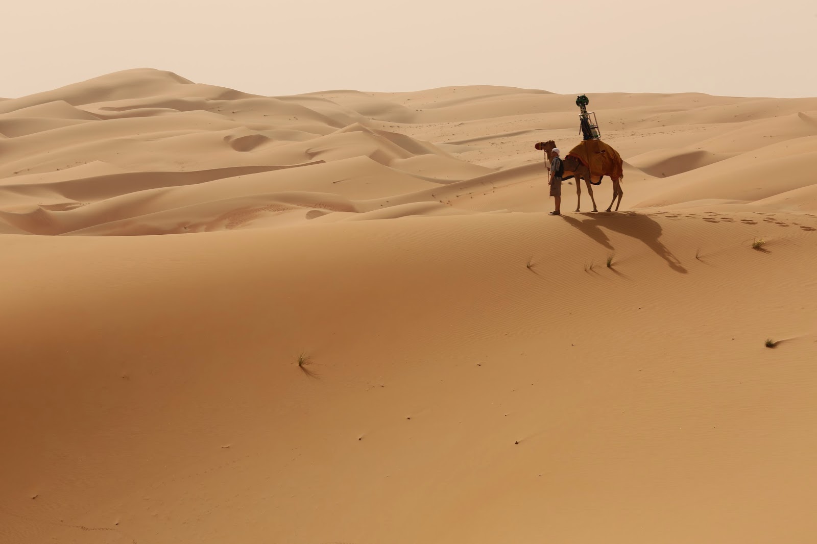
No, that’s not where Apple Maps will take you when you ask for directions to Starbucks, but close! It’s the Liwa Desert in the United Arab Emirates, and Google Maps has captured the site in detail for exploring through Street View thanks in part to camels:
To bring this stunning desert to Street View, we fashioned the Trekker to rest on a camel, which gathered imagery as it walked. Using camels for the collection allowed us to collect authentic imagery and minimize our disruption of this fragile environment.

Street View continues to be one of the most robust features with Google Maps, and the team has recently added some remarkable locations to the Street View collection. Shared today on the company’s Europe blog, Google Street view has added new imagery of scenes from around the Swiss Alps in Switzerland:
Together with the Swiss Alpine Club (SAC) and the Swiss Tourism Board (MySwitzerland.com), we launched a contest called “Queen of the Alps.” High in the Swiss Alps, far from any road or other buildings, are picturesque huts used to spend a night by farmers and vacationers.
It often takes a full day hike to reach these out of the way huts. We ran online vote to find the favorite Swiss hut, promising to film the choice for Street View. The Swiss Alpine Club’s Lauteraarhütte-SAC in the canton of Berne (region “Grimselgebiet”) won. It took our Trekkers a five hour hike up the Grimsels Hospiz to capture this exciting imagery.
The Street View film crew also toured and captured the Winter Olympic venues in Sochi, Russia, including the Sochi Formula 1 racing track:
Stroll around the Fischt stadium which hosted the opening and closing ceremonies. Walk on the Ice Palace “Iceberg” and visit the Olympic Village, where your favorite team stayed.
In particular, take a look at the new Formula 1 track in Sochi. It is located in the city’s Olympic Park and is the only Formula 1 track in Russia. From October 10-12, Russia will host its first World Championship race.
As you can see above, you can actually tour the Formula 1 racing track as if you were behind the wheel of the car. Just search the venues on Google Maps.
Google Street View cars have been busy, adding Mason and Grand Ledge in the U.S., expanding coverage of Malaysia and adding in Argentina, reports the Google Earth Blog – the Grand Ledge Opera House shown above. This follows Google adding Cambodia and Indonesia last month.
Google has already added historical Street View links to a few locations in Argentina, the dates indicating that Google has been collecting the imagery for around a year.
Google’s Street View cars are doing more than taking photos these days, the company using some of them to detect methane leaks from corroded pipes, landfill sites and other sources. The company’s more notorious form of data-collection – wifi sniffing – resulted in a $7M settlement, the U.S. Supreme Court rejecting its attempt to appeal the lawsuit.
Street View is much more than a tool for taking an early look at the local scenery of an upcoming road trip, it’s now an easy and affordable way to see parts of the world that were once limited to a privileged group of jetsetters. Today Google announced the addition of a grand new virtual tour that lets you visit some of the biggest monuments of Ancient Egypt from the comfort of your computer.
Google has added a gorgeous new set of Street View imagery, quoting Tales of Iceland author Stephen Markley in describing the views as “soul-enriching, breath-taking, life-affirming” …
Expand
Expanding
Close

Google announced today that it’s added Street View imagery for a long list of new university campuses in Google Maps. The new schools, which include campuses across the U.S. and Canada, are available to explore starting today.
Google notes that these new additions add to the hundreds of school campuses you can already explore in Google Maps. It highlighted a few of the new campuses rolling out today in its announcement including Georgetown University, University of Miami, and the University of Regina in Canada.
To see if a Street View tour of your dream school is available, search for a particular university on Google Maps and click on Pegman to enter the Street View imagery. Visit our Street View gallery for global highlights and other popular universities around the world.

Google announced today the availability of 76 historical sites in India that can be viewed from Google Maps or through the Google Cultural Institute site. These 360-degree photos will let you take a tour of the Kangra Fort without having to pack a single bag. Thanks to support from the Archaeological Survey of India (ASI), along with previous efforts, Google’s imagery of historic shots of India has surpassed 100 pictures, with locations like the Taj Mahal and Humayun’s Tomb already available to view.
New Scientist reports that Google is now using Street View cars to detect methane leaks from corroded pipes, landfill sites and other sources.
Sensors strapped to the top of the cars have mapped hundreds of methane leaks around Boston, New York’s Staten Island and Indianapolis […]
Methane leaks are a triple threat: they can cause explosions, accelerate the growth of global warming and waste money. A study last year found that US methane emissions are 1.5 to 1.7 times higher than current estimates, a discrepancy that has been attributed to hard-to-detect leaks …
Amidst the ‘controversy’ of the recently-introduced ‘right to be forgotten‘ on Google, the Independent reports that celebrities and other public figures are asking Google to blur the Street View images of their homes. Musicians Paul McCartney, Jimmy Page, Lily Allen and Katherine Jenkins are amongst those named as having taken advantage of the Google tool to request this. Google’s Street View privacy page says that in addition to the blurring it already does automatically (including faces, some street numbers and some homes), additional blurring is done on request.
We provide easily accessible tools allowing users to request further blurring of any image that features the user, their family, their car or their home. In addition to the automatic blurring of faces and license plates, we will blur the entire car, house, or person when a user makes this request for additional blurring.
(via Gizmodo)
The US Supreme Court rejected Google’s attempt to appeal a class-action lawsuit claiming the search giant violated federal wiretap laws when its Street View vehicles collected data from private WiFi networks. In 2010, Google said that it accidentally recorded data from unencrypted WiFi networks, stating it immediately grounded its cars and reached out to regulators to find out how to properly dispose of the information that it collected.
WebUrbanist drew our attention to a Tumblr blog that captures the sad decline of Detroit from 2009 to 2013 using images captured from Google’s Street View time machine.
Back in April, Google added a clock icon to the top-left corner of images, which opens out into a slider that allows you to see the same image photographed at different times …
Expand
Expanding
Close
The 2014 World Cup is set to kick off next week in Brazil, and Google seems to be excited about the event. Earlier this week the company updated the Chromecast with support for WatchESPN streaming, meaning that all 64 World Cup games will be able to be streamed to the device. Now, in a post on the Lat Long blog, Google has announced some new features for Maps exclusively for the World Cup.
Expand
Expanding
Close
Police in Edinburgh, Scotland, were called out to investigate when someone using Google Street View thought they’d spotted an axe-murder, reports the Independent. The series of images apparently showed someone being struck with an axe and the assailant walking away from the lifeless body on the ground.
The scene turned out to be a prank by a couple of quick-thinking mechanics who said they had 20 seconds to think of something to do when they spotted the Google car approaching.
“It was in the spur of the moment,” Dan Thompson said. “It seemed like the obvious thing to do so I threw myself on the ground and Gary [Kerr] grabbed a pick-axe handle from the garage.
“We only had about 20 seconds – it was all we could think of.”
The way that Google stitches Street View images together, which often leave visible breaks, added to the illusion, seeming to show a chopped-off hand.
The pair of jokers said that fortunately the two police officers who turned up to check it out saw the funny side.
They were already pretty certain it was a joke because one of their colleagues gets their car serviced here. They thought it was a really good laugh and in five minutes they were gone.
Certainly beats mooning or a couple getting amorous.
The impact of climate change is a hot topic and many environmentalists are urging the powers that be to take action. To help spread awareness and promote World Environment Day on June 5th, an eco-friendly crowdfunding outlet by the name of CarbonStory has put together an interactive website called World Under Water. Available exclusively on Chrome, this modified version of Street View paints a dramatic picture of what the world’s cities will look after sea levels have risen.

Although most human eyes struggle to see them clearly, Google has developed a software that can crack most CAPTCHAs. In a paper published earlier this week, Google researchers from its Street View and CAPTCHA teams discuss a new algorithm capable of solving the company’s jumbled text security puzzles with an accuracy rate of 99.8 percent.
[youtube=https://www.youtube.com/watch?v=IdVXrVxziXc]
Senior Vice President of Conservation at American Rivers Chris Williams announced today on the Google Maps blog that the organization has partnered with Google to add high-resolution imagery of the Colorado River running through the Grand Canyon to Street View:
Start at an iconic spot like Deer Creek Falls or North Canyon, or climb up to the Nankoweap Granaries. Geology fans will enjoy formations like Hermit Shale and Tapeats Sandstone. On your journey, look out for wildlife like big horn sheep and signs of a volcanic dam that naturally occurred centuries ago.
The project was an important one, as Google noted in its blog post, the Colorado River has long been at risk:
While you admire its grandeur, remember that the river is also at risk. One of the United States’ most important resources, the Colorado River provides drinking water for 36 million people from Denver to Los Angeles, supports a $26 billion recreation industry, and irrigates nearly 4 million acres of land that grow 15 percent of our nation’s crops. But it’s also one of the most endangered, dammed, diverted and plumbed rivers in the world, thanks to a century of management policies and practices that have promoted the use of Colorado River water at an unsustainable rate. By the time it reaches the Gulf of California in Mexico, the river is barely a trickle—a ghost of its once magnificent self. You can see evidence of the river’s decline In Street View, like the high water mark (showing 1950s driftwood on top of the rock), or sedimentation along the river’s edge down by Lake Mead.
Google has a new collection of imagery from the Colorado River here and a new webpage taking you behind the scenes of the project here.
Search for Agloe, NY, in Google Maps and the small town will duly appear. Which is odd, as Agloe doesn’t exist, and never has.
BigThink reports that Agloe was one of a number of ‘paper towns,’ places that were invented by early map-makers back in the 1930s in order to catch out rival companies who stole their work.
How do you prove someone stole your map, if that map accurately reflects reality? The answer: add fantasy! Mapmakers had been able to take their competitors to court by pointing out fake places (a.k.a. paper towns) on their maps that were copied from their original work! For this reason, fictitious roads are often called trap streets: because they entrap the company copying them onto their own maps …
Expand
Expanding
Close
While technology hasn’t quite reached the stage of allowing us to watch the Winter Olympics from within Google Street View, you can now take a virtual wander through the host city of Sochi. The games are scheduled to take place there from 7th to 23rd February.
Street View coverage in Russia also now includes Vladivostok, Irkutsk and Yakutsk – though you may want to put on your coat for the latter: as the city with the greatest seasonal temperature swings on Earth, the lowest recorded winter temperature was a bracing -83.9F (-64.4C).
Google also added its first imagery in Slovenia, making the central European nation the 56th country to be added to Street View.
Check out some other cool (not all of them quite so literally) places you can visit on Street View with our roundup here.
[youtube=http://www.youtube.com/watch?v=vi-ljpuEGnA]
The latest area to be added to Google Street View is the test track from the original British version of Top Gear, with the imagery featuring The Stig challenging the Google car to a race in a Mercedes-Benz SLS AMG …
Expand
Expanding
Close