Google Street View


Google Street View is known for the sometimes hilarious moments that it catches, and also for its remarkable ability to recognize human faces and blur them. I guess you might be able to call this case an amusing combination of both. In a screenshot grabbed by one Twitter user, it seems Google has (accidentally, probably) blurred out the face of a cow…


Street View is now a feature we take for granted in all our mapping services, but in 2007 it was a very ambitious effort by Google to photograph the world. The feature on the latest version of Google Maps on Android received a slight revamp to make navigation on mobile easier.
Google is constantly on a quest to add new, interesting visual tours to its popular Maps service, and its latest addition will help give you a taste of the Olympic venues ahead of this year’s competition in Rio de Janeiro, Brazil.

For most people, Google Map Street Views are their first interaction with 360 degree images. As people have begun to associate other 360 degree content as Street Views, Google will be taking advantage of the recognition. At today’s LG G5 event, Google announced that from now on shared Street Views will be stored in high quality for free.
Since it launched in 2007, Google Street View has captured both mundane and exotic locations, spanning from your front yard to majestic mountains and ancient cities from around the world. Most recently, the portable Street View backpack was spotted at Disney’s Magic Kingdom and Epcot parks in Florida…
Google has partnered with a number of outdoor explorers, photographers, runners, skiers and filmmakers to take us closer than ever before to highest mountain in the Alps. Google’s new virtual exploration is simply breathtaking, and easily worth a few minutes of your time…
In order to help monitor and show the effects climate change is having on the world around us, Google has teamed up with a number of global organizations to photograph various areas using its 360-degree Trekker camera. Using Street View in Google Maps, you can now take tours of a remote Manitoba habitat, some of the Amazonian rainforest and a Californian nature reserve…

When it comes to ancient cities, they don’t come much more exotic than Petra in Jordan, made famous by Indiana Jones and the Last Crusade, and that’s where Google’s Trekker takes us with its latest Street View imagery. Google handed over its blog post announcing it to Queen Rania of Jordan.
To this day, after too many trips to count, Jordan’s ancient archeological site, the Rose-Red city of Petra, still fills me with awe. Concealed in majestic mountain gorges, visitors can wander through the entire city of Petra, imagining what life was like in the thriving trading center and capital of the Nabataean kingdom. Carved by hand into vibrant red, white and pink sandstone cliffs, it has, miraculously, survived earthquakes to withstand the test of time …

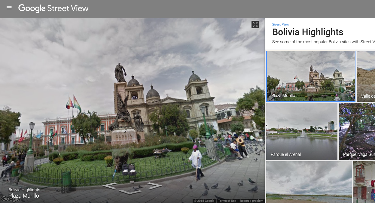
Street View has been slowly getting more locations since it launched in 2007, and now the company has added many of parts of Bolivia and Ecuador to the list. These two South American countries are full of history and beautiful imagery, and now they can be explored from the comfort of your Chrome browser.
Google is even featuring some of the best imagery from Bolivia and Ecuador on its Street View site.
Just a couple of months ago, Google launched a standalone Street View app for Android and iPhone. Android users will find it on the Play Store, and iPhone users can download the standalone Street View app on the App Store. And if you’re interested in exploring Bolivia and Ecuador in VR, you might be interested in the fact that the Street View app recently added support for Google Cardboard.
The backpack-based Google Trekker tours have taken us to some pretty spectacular places in the past, and the latest addition won’t disappoint. The Street View imagery covers seven of New Zealand’s world-famous ‘Great Walks,’ including some of the settings for the Hobbit movie trilogy …
Expand
Expanding
Close


Digisfera, a startup that prides itself in “photography, design, and development services for projects involving 360° images,” has been acquired by Google. Financial details of the deal haven’t been revealed, but Digisfera’s website has been updated to reflect the acquisition and states that the group is joining the Street View team at Google to “continue building great experiences using 360° photography.”
Here’s the full statement from the team:
We’re excited to share that Digisfera is joining Google. We started Digisfera almost five years ago and have had the opportunity to work in many interesting projects involving 360º photography over the years. We’re excited to join the Street View team at Google to continue building great experiences using 360° photography.
As we move on to our next adventure, it will no longer be possible for us to keep developing PanoTag, so it is being discontinued. We are planning to open-source our Marzipano viewer in the coming weeks and hope this will benefit the panoramic photography community.
The Portugal-based startup, according to reports, has been part of capturing many significant moments in panoramic photography, including Barack Obama’s inauguration, landmarks in Rio de Janeiro during the 2014 World Cup, and parts of the 2014 Winter Olympics. These skills are going to hopefully translate to making Street View a better product and it wouldn’t be far-fetched to think that Digisfera could contribute to Cardboard technology as well.
The company says it plans to open-source its Marzipano panorama viewing software.

If you aren’t yet aware, Google released a standalone Street View app for Android last month — and with it comes a showcase of all the best Street View imagery right at your fingertips. While previous versions of the app have allowed you to use your phone’s gyroscope to look at the Street View photography in 3D, the latest version of the app brings a great feature for VR fans: Google Cardboard support…
To access the feature, all you have to do is make sure you have the latest version of the app (which is rolling out now on Google Play, and alternatively available now over at APKMirror). Once you open the app, all you have to do is navigate your way to a view that you’d like to look at, rotate your phone 90 degrees, and tap the new Google Cardboard icon at the top-right of the screen.
If you’re like me, you sometimes use the Street View feature of Google Maps to see a place you’re about to visit and what its surrounding area looks like. Maybe you’re apartment hunting and want to see if the neighborhood looks safe. Regardless of why you do it, Google understands us and has made this previewing a tad easier.
Google Maps version 9.13.0 for Android places a thumbnail preview of a location in the bottom left corner of the screen for inputted addresses and places for which you’ve pressed and held on the map. It looks like this:

Tapping one of these previews brings up your standard Street View:

This version is available from Google Play, and an APK can be downloaded from APKMirror.

Aclima, a startup which builds an end-to-end hardware and software solution for detecting and analyzing the health and state of varying environmental surroundings (i.e. indoors where carbon dioxide can build in meeting rooms, outdoors where vehicles can release significant carbon monoxide), has announced a new partnership with Google which will see its sensors make their way onto Google Street View cars in the San Francisco Bay Area. Street View cars are the vehicles through which Google collects street-level imagery for its Maps street view product.
The ultimate goal for Aclima with partnerships including this one is to make data on air quality as easily accessible as the weather so that communities can better understand how air pollutants in their area are affecting human health and climate change, and start a dialog on improving local air quality.


Google’s self-driving cars are drawing a lot of attention and conversation online. Perhaps one of the biggest concerns from regular people like you and I is how safe they are. But as a recent video and blog post shows, you’re seemingly infinitely far more likely to be hit by another driver not paying attention, than your car malfunctioning and crashing in to someone else. But why do Google’s cars get hit so much?
Chris Urmson posted a really interesting article about what it’s like being hit by another car, driven by a human, while taking a ride in a self-driving Googlemobile. Urmson notes that the autonomous cars are being hit “surprisingly often”, despite their fancy array of sensors, processors and algorithms.

Googlers use their 20% in many different ways, and usually that means building a product or service they hope will someday see some amount of wider adoption. Gmail and AdSense were both built in 20% time, and now they’re two of Google’s biggest services.
Nat & Lo are going to do something a bit different. Since most people don’t ever get a chance to really see how Google ticks behind the scenes, Nat & Lo thought they would use their 20% time to show us — and they’re doing so via a newly-launched YouTube channel.
Expand
Expanding
Close
Yosemite’s El Capitan is one of the most famous rock-climbing locations in the world. Once considered impossible to climb, the 3000-foot route is still one of the most difficult climbs around. So naturally when the Google Street View team asked El Capitan veterans Lynn Hill, Alex Honnold and Tommy Caldwell to attempt it with the added challenge of 360-degree camera gear, they jumped at the chance.
Climbing is all about flirting with the impossible and pushing the boundaries of what you think you can be done. Capturing Street View imagery 3,000 feet up El Capitan proved to be an extension of that, especially when you take a camera meant for the inside of a restaurant and mount it thousands of feet up the world’s most iconic rock wall.
The imagery captured combines conventional stills of the climbers at work with the 360-degree cameras needed to allow you and I to join them in a virtual climb of the entire route …
Expand
Expanding
Close
Google is marking World Oceans Day, on Monday, with underwater Street View imagery in three amazing locations: Bali, the Bahamas and back to the Great Barrier Reef. The Google Maps blog says that the company wanted to draw attention to the environmental damage we are doing to our oceans.
Home to the majority of life on Earth, the ocean acts as its life support system, controlling everything from our weather and rainfall to the oxygen we breathe. Yet despite the ocean’s vital importance, the ocean is changing at a rapid rate due to climate change, pollution, and overfishing, making it one of the most serious environmental issues we face today.
The company says that mapping the ocean not only showcases its beauty, but also provides baseline imagery which can be used to monitor changes and highlight threats …
Expand
Expanding
Close
Madagascar is an island off the coast of Southeast Africa, formed around 88 million years ago, its plants and animals forming in relative isolation from the rest of the world. Over 90% of its wildlife is found only on the island – and you can now take a virtual trip there thanks to the latest Street View imagery from Google’s Trekker system …
Expand
Expanding
Close
[googlemaps https://www.google.com/maps/embed?pb=!1m0!3m2!1sen!2sus!4v1422413696276!6m8!1m7!1sS6MvpZwWN03vSEO4uV8KzA!2m2!1d45.394028!2d-75.691904!3f88.79!4f11.010000000000005!5f0.7820865974627469&w=704&h=400]
Google is always expanding the imagery available in its Street View feature in Maps, and this evening the company has announced in a blog post that it has added new data from the Rideau Canal Skateway in Ottawa. The city is set to kick off its annular Winterlude Festival next week, which is a three-week long event that hosts a variety of games, shows, and activities.

Google is constantly bringing new imagery to its Street View feature in Maps, and this week the search giant is highlighting new additions from around Belgium. In what it describes as “some of the best of Belgium”, the new Street View data shows off five different locations including the inside of a castle and a World War II memorial.
Expand
Expanding
Close
If you have ever wanted to experience the Northern Lights without traveling to countries such as Iceland, Finland, Norway and Sweden, look no further than Google Maps. Starting today, it is now possible for people from all over the world to explore the Aurora Borealis through Street View on Google Maps.
Expand
Expanding
Close
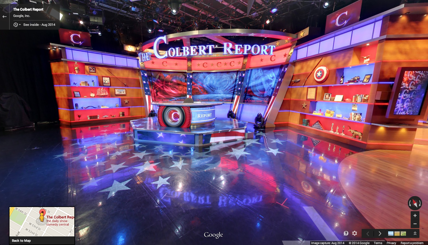
With Comedy Central’s The Colbert Report officially coming to an end tonight and host Stephen Colbert moving on to “The Late Show” next year, Google today added a virtual, 360-degree tour of the show’s studio to Google Maps.
Google is promoting its Google Maps Business View feature, which allows businesses and others to add the indoor virtual tours to Maps to complement the Street View imagery it has long offered for navigating outdoors.
The series concludes tomorrow, but you can still feel like you’re in the audience (or relive the good ol’ days) with a brand-new virtual tour of the studio. And the show has created an interactive experience with the Business View imagery that lets you explore and remember some of your favorite moments from the show. And for those who want to tour more entertainment and news studios, check out our Views gallery.
As always, Google reminds that Business Views feature is available across platforms in Maps whenever a “See Inside” marker appears over locations. Google says it has already added indoor imagery for hotels, restaurants and retail locations in over 30 countries.
The world’s cheapest virtual reality headset may be just a bit of fun by Google, but the company hasn’t just put it out there and forgotten about it. An easter egg in Google Maps for Android lets you use Google Cardboard to take a virtual reality tour of places like the world’s tallest building – Dubai’s Burj Khalifa.
Double-tap the navigation icon bottom-right to activate VR mode, then view through Google Cardboard.
Google recently announced that half a million people are using Cardboard as it offered new SDKs to software developers and opened a dedicated section of the Google play store for cardboard apps.