Google Maps

Google today has announced that it is expanding support of lane guidance in Maps for Android to 15 additional European countries. The feature was launched in the United States and Canada last year, with Google promising expansion at a future date. Ireland, France, Germany, Italy, and the United Kingdom gained support for lane guidance in December.
Today’s update adds lane guidance to the following 15 European countries:
Expand
Expanding
Close

Google today has started rolling out an update to its Maps app on Android that bumps it to version 9.4. Most notably, the update adds integration with Google’s new Local Guides service, which it originally introduced back in January. Previously called City Experts, Local Guides is the company’s efforts to get users to review local businesses and share them with others.
Google announced today that it’s making Google Earth Pro free to all, bringing the ability to do things like “measure 3D buildings, print high-resolution images for presentations or reports, and record HD movies” inside Google Earth.
The previously paid advanced Google Earth features were previously used by mostly businesses, scientists and hobbyists, according to Google.
Starting today, even more people will be able to access Google Earth Pro: we’re making it available for free… Whether you’re planning a new office building or a trip to the mountains, check out Google Earth Pro and see how easy it is to visualize your world.
Google is allowing anyone to get a free key to Google Earth Pro by signing up here. The Google Earth Pro app for PC and Mac is available to download here.
[youtube http://youtu.be/SGTRTHr-BDw]
[googlemaps https://www.google.com/maps/embed?pb=!1m0!3m2!1sen!2sus!4v1422413696276!6m8!1m7!1sS6MvpZwWN03vSEO4uV8KzA!2m2!1d45.394028!2d-75.691904!3f88.79!4f11.010000000000005!5f0.7820865974627469&w=704&h=400]
Google is always expanding the imagery available in its Street View feature in Maps, and this evening the company has announced in a blog post that it has added new data from the Rideau Canal Skateway in Ottawa. The city is set to kick off its annular Winterlude Festival next week, which is a three-week long event that hosts a variety of games, shows, and activities.
Google is constantly bringing new imagery to its Street View feature in Maps, and this week the search giant is highlighting new additions from around Belgium. In what it describes as “some of the best of Belgium”, the new Street View data shows off five different locations including the inside of a castle and a World War II memorial.
Expand
Expanding
Close

Two of the biggest tech companies in the world–Google and Apple–couldn’t be more different in their philosophies. Apple has always believed in doing a very few things very well, famously saying no to a thousand things for every time it says yes. Google, in contrast, has tried to do– well, almost everything, including things well in the realms of science fiction.
Steve Jobs and Larry Page spoke about this difference shortly before Jobs died, with the Apple co-founder urging Page to “figure out what Google wants to be when it grows up.” Jobs expressed the view that, without focus, Google was in danger of turning into the next Microsoft, creating a large number of ok products but none of them with any wow factor …
Expand
Expanding
Close
Google today released a set of improvements to the Google Maps APIs for developers looking to use transit directions in their Android apps. Specifically, users can now receive fare info where available and make use of the same mode and routing options as the Google Maps app.

It appears that Google could soon release its promised redesigned Calendar app for iPhone after first making the announcement and releasing the app for Android last November. The Next Web this morning shared a handful of leaked screenshots that provide a first look at Google Calendar for iOS, including info cards that indicate Gmail, Photos and Maps integration will be key features of the app.
Expand
Expanding
Close

Google has today relaunched its review program previously called City Experts as Local Guides, and hopes to engage the community and get more people involved through what looks to be some much more friendly branding and fun new features. While Google previously touted the “exclusive benefits” you could receive through the program and required “50 high-quality reviews” for entry, the new program instead suggests that you “help others and support businesses” and encourages you to “be yourself.”

If you have ever wanted to experience the Northern Lights without traveling to countries such as Iceland, Finland, Norway and Sweden, look no further than Google Maps. Starting today, it is now possible for people from all over the world to explore the Aurora Borealis through Street View on Google Maps.
Expand
Expanding
Close
After a relatively quiet Update Wednesday, Google this evening has picked things up by rolling out an update to Google Maps on Android, bumping the app to version 9.3. The update is not chock full of features, but there are certainly a few things avid users of the app will appreciate.
Google Maps is today releasing imagery of iconic holiday window displays from retailers in London and New York, allowing users to get a Street View-style experience of the elaborate Christmas and holiday decorations that a few big retail stores are known for.
The Street View Windows Displays include Saks Fifth Avenue, Macy’s, and Bloomingdale’s in NYC, and Liberty and Selfridges in London.
Half the fun of holiday shopping is seeing the lavish, seasonal displays in the windows of shops and department stores as you pass by. Starting today, with Google Maps Business View, you can see decked out displays in New York and London—without braving the cold weather, lugging bags around or fighting for sidewalk space with fellow shoppers. Now grab your virtual reindeer because we’re off to our holiday window tour!
The feature is yet another way Google is attempting to promote its Google Maps Business View feature, which allows businesses and others to add the indoor virtual tours to Maps to complement the Street View imagery it has long offered for navigating outdoors.
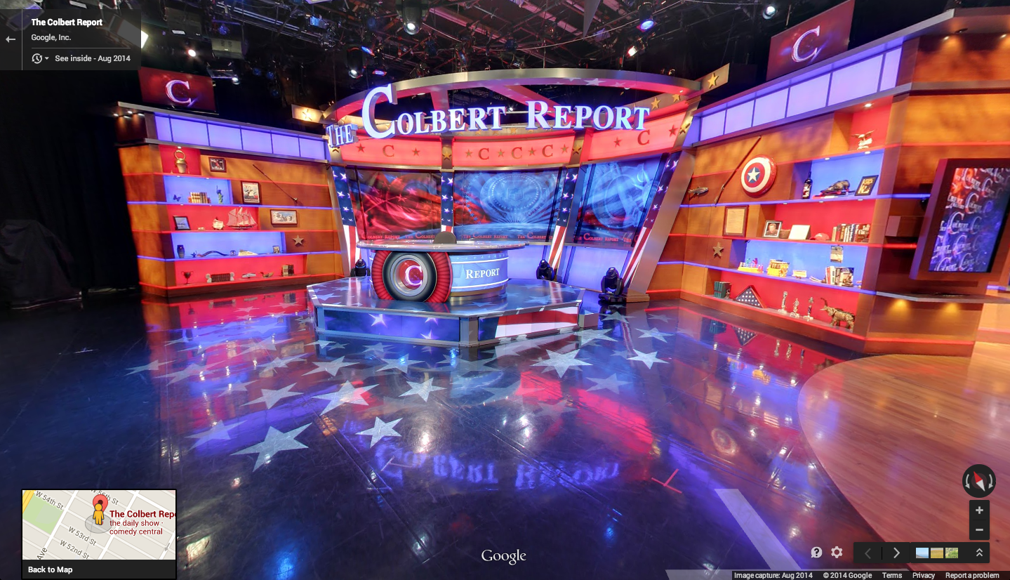
Earlier this week Google added a virtual, 360-degree tour of The Colbert Report studio ahead of the show’s final episode.
With Comedy Central’s The Colbert Report officially coming to an end tonight and host Stephen Colbert moving on to “The Late Show” next year, Google today added a virtual, 360-degree tour of the show’s studio to Google Maps.
Google is promoting its Google Maps Business View feature, which allows businesses and others to add the indoor virtual tours to Maps to complement the Street View imagery it has long offered for navigating outdoors.
The series concludes tomorrow, but you can still feel like you’re in the audience (or relive the good ol’ days) with a brand-new virtual tour of the studio. And the show has created an interactive experience with the Business View imagery that lets you explore and remember some of your favorite moments from the show. And for those who want to tour more entertainment and news studios, check out our Views gallery.
As always, Google reminds that Business Views feature is available across platforms in Maps whenever a “See Inside” marker appears over locations. Google says it has already added indoor imagery for hotels, restaurants and retail locations in over 30 countries.
Google released its Photo Sphere Camera app for iPhone users a few months back with the ability to capture 360º images right from your device and share them over social media or even Google Maps.
Photo Sphere Camera can also be used without ever publishing images anywhere or sharing photo spheres with anyone, so today Google added tabs to the app’s library separating public and private photos.
Expand
Expanding
Close
Google announced today that it’s adding the Google Maps lane guidance feature it rolled out to select locations earlier this year to additional countries just in time for the holidays. Google said today that Maps now includes lane guidance for highways in Germany, France, Italy, Spain, the UK, and Ireland.
When you’re in the turn-by-turn navigation mode, we can now make sure you don’t miss your next turn or exit by showing you which lane to stay in or move to so you’ll never find yourself darting across traffic at the last minute — or worse, driving for miles down the wrong road. When you approach a junction or exit with multiple lanes, voice guidance will suggest which lanes are best for your route. You’ll also have easy access to alternate routes while you’re navigating, so you can choose the best drive for you.
Google first announced the feature back in May, which offers real-time info to help drivers prepare for upcoming turns or necessary lane changes, and it’s been rolling out to select countries and locations since.
The lane guidance feature is available through turn-by-turn Navigation in the Google Maps app on Android and iPhone.
Google is rolling out a completely redesigned version of its iPhone and iPad app with its Material Design look and feel right down to the app icon.
The latest version of the search app now presents a bottom navigation bar (which can slide out of view) that presents a persistent Google button for searching for new information. The navigation bar also offers a button for quickly accessing recent search pages, something that feels similar to multitasking between apps on Android.
Also notable as part of the redesign is the optimization searching for photos has received. In the latest version of Google’s iOS app, image results now take on a full-screen, mosaic look for presenting larger results. The update also packs in deep Google Maps integration for location searches including support for Google Street View right in the app for iPhone users. You can read the full change log below:
Expand
Expanding
Close

Google has today updated the 3D imagery in both Google Earth and Google Maps, taking advantage of newer cameras to provide much better accuracy and a more realism in select United States cities. The newer imagery can be seen on the left in the image above, where it’s obvious that the San Francisco City Hall building’s contours and architecture now have much greater clarity.
Google says that the first two cities to get this treatment are the San Francisco Bay Area and New York City, New York. But while these two cities are the first to see the update, they definitely won’t be the last. More cities will be getting the new imagery throughout 2015, according to Google.
To give you another look at the new imagery, here’s the new view of the Statue of Liberty (left is new, right is old):

As you can see below, there’s also new imagery that only recently became possible. The new 3D view includes the relatively new Six World Trade Center in New York, and there’s also new imagery of the Bay Bridge:

Google announced today that it’s making its custom map creation tool called Google My Maps available to users inside of Google Drive. That means that that custom map tool will appear as a Drive app alongside the usual Google Doc, Sheet, Slides, Drawings, etc (as pictured above).
Expand
Expanding
Close

Google and Santa have a lot in common. They know when you are sleeping/awake. They also give you cool stuff but also freak you out a little bit sometimes.
Well, Google also keeps tabs on Santa and for the umpteenth consecutive year Google is following Santa on his round the world trip from the North Pole on Christmas. This year’s tracker has some fun games to play every day but this year you might actually learn a thing or 2:
This year, you’ll find an edu touch — new geography games let you explore local holiday traditions, while a new coding project teaches basic JavaScript as you help Santa and the reindeer navigate the map. Learn how to say “Santa” in different languages, and connect with nonprofits around the world.
Of course, fan favorites are making a return this year — you can send a call from Santa to your friends and family, display Santa’s journey on the TV screen with Chromecast, and play gumdrop and reindeer racing games. You’ll be able to play each game on desktop, mobile web, or on the Santa Tracker Android app.
Jump on board with the Android app, Chrome extension or website or follow Google Maps on Google+, Facebook and Twitter in the countdown #tracksanta.
[googlemaps https://www.google.com/maps/embed?pb=!1m0!4v1416448266011!6m8!1m7!1s9WgYUb5quXDjqqFd3DWI6A!2m2!1d46.41438376976309!2d10.01394735785013!3f210!4f10!5f0.7820865974627469&w=704&h=400]
Google, in a post on the Geo Developers Blog, today announced the ability for website owners to embed Street View panoramas and Photospheres within their site using an HTML snippet. Google launched this feature for Maps last year, but only today did it add support for Street View and public Photospheres.
Today, we added the ability to easily embed the Street View and Photo Sphere images you find in Google Maps and we’re also enabling the same capabilities programmatically in the Google Maps Embed API. These embeds use the new imagery viewer technology that powers Street View in the new Google Maps.

With today marking Veterans Day, Remembrance Day and Armistice Day in the United States and countries that belong to the Commonwealth of Nations, along with several other regions worldwide, Google announced this morning that users can now tour some significant U.S. historical places in Street View on Google Maps.
Expand
Expanding
Close

Google announced a new update for its Google Maps apps for Android and iOS today that adds a fresh new Material Design layout focusing on bright colors and real world surfaces and shadows. The software’s refreshed interface is set to roll out over the next few days, with new features like dinner reservations from OpenTable (US only) and enhanced information cards with photos and reviews of popular attractions near your location.

One from The Dept of You Couldn’t Make It Up. A court has awarded a Canadian woman $2,250 in damages against Google for showing her cleavage in a Street View image, reports Le Journal de Montréal (via GigiOM).
Photographed by a Street View car in 2009 while sitting on her stoop leaning forward in a low-cut top, the judge ruled that Mario Pia Grillo suffered shock and embarrassment when co-workers spotted the image.
Google had automatically blurred her face, but the court accepted her argument that she was identifiable from the fact she was sitting outside her own home. Google subsequently blurred her entire home.
Quebec’s legal system is modelled on that of some European countries, like France, where you retain a right to privacy against intrusive photography even in a public place.

If visiting historical landmarks in Egypt from the comfort of your smartphone wasn’t enough, virtual jetsetters can now take a tour of Luxembourg without leaving their home thanks to Street View. Historical sites like the medieval Grund neighborhood and the Kirchberg center for European Union buildings are now at your fingertips.