Google Earth


Following today’s Google Earth revamp announcement, the YouTube channel Nat & Friends, previously Nat & Lo, released a behind the scenes video explaining how Google Earth was created…
Google teased that it would be launching a ‘brand new experience’ for Google Earth, and it has today announced the details.
The biggest change is that Google Earth is no longer a standalone app on desktop: it now runs as a web app. As of today, it’s Chrome-only, but the company is promising support for other browsers later. The mobile version still requires an app, and is currently Android only, with iOS support promised.
There are, though, two headline new features …
Google has sent out press invites to ‘the unveiling of the new Google Earth‘ on April 18. The company gives no clue what to expect, but promises a ‘brand new experience.’
As Engadget observes, the smart money has to be on new virtual reality features …
Google Earth Enterprise was originally released over 10 years ago, allowing businesses to build and hosts private versions of Earth and Maps. Back in 2015, however, Google announced that it was shuttering the service come March 2017.
The company today slightly revised those plans, saying that it would open-source all of the core Google Earth Enterprise tools.
Launched in 2013, Timelapse is a global, zoomable map built on top of the Google Earth Engine that allows you to explore how a location has changed from 1984 to 2016. A huge update today adds petabytes of new data and an additional four years of imagery that makes for sharpest historical view of Earth ever.
In the mid-2000s, one of the coolest pieces of software to play around with was Google Earth. That experience is now coming to high-end virtual reality headsets with Google Earth VR. For the moment, it is available for free on Steam, but only for the HTC Vive.
The novelty of exploring satellite imagery of the world in Google Earth has long worn off since the app launched in 2001. Now the the company has given you a reason to dive back in and explore the Earth from above, announcing today that all mapping products, including the satellite layer in Maps, will get sharper and more detailed images thanks to a new satellite and processing techniques…
Transportation service Uber has hired a longtime mapping expert from Google as the company focuses on boosting its own mapping expertise. As Recode reports, Brian McClendon has left his engineering VP role at Google to oversee Uber’s Advanced Technologies Center. McClendon previously led development for Google Earth and Google Maps and has worked for the company for 10+ years…
Expand
Expanding
Close

Google announced today that it’s making Google Earth Pro free to all, bringing the ability to do things like “measure 3D buildings, print high-resolution images for presentations or reports, and record HD movies” inside Google Earth.
The previously paid advanced Google Earth features were previously used by mostly businesses, scientists and hobbyists, according to Google.
Starting today, even more people will be able to access Google Earth Pro: we’re making it available for free… Whether you’re planning a new office building or a trip to the mountains, check out Google Earth Pro and see how easy it is to visualize your world.
Google is allowing anyone to get a free key to Google Earth Pro by signing up here. The Google Earth Pro app for PC and Mac is available to download here.
[youtube http://youtu.be/SGTRTHr-BDw]
Google today announced that it is sunsetting the Google Earth API. The company says its reasoning for shutting the API is that both Firefox and its own Chrome browser are removing support for Netscape Plugin Application Programming Interface plugins due to security reasons. A lack of cross-platform support, specifically on mobile devices, also contributed to the decision to shutter the Earth API.
London may be an expensive tourist destination, but Google will soon offer the next best thing to hopping on a plane: complete 3D imagery of the entire city. The London Evening Standard reports that every building in London will soon be included.
A Google Maps spokesman said: “Using 45-degree aerial imagery, we’re able to recreate entire metropolitan areas in 3D. This means every building, not just the famous landmarks, the terrain, and any surrounding landscape of trees are included to provide a much more accurate and realistic experience of the city” …
In a blog post on its official enterprise blog today, Google announced that it is opening up its collection of Google Earth data to businesses. Businesses and governmental organizations will now have the ability to purchase imagery collected by Google and use them for whatever they need. Since it launched 9 years ago, Google Earth has built up an incredible collection of image data, and it only makes sense for the company to continue to profit off of it.
An interesting story from the BBC goes behind the scenes with the satellites that are used to take imagery of earth that eventually land in Google Maps and Google Earth.
Behind a long rectangular window, in a high white room tended by ghostly figures in masks and hats, a new satellite is taking shape. Once in orbit later this year, WorldView-3 will be one of the most powerful Earth observation satellites ever sent into space by a private company. Spinning around the planet some 600 kilometres (370 miles) above us, it will cover every part of the Earth’s surface every couple of days.
Google gets the majority of its imagery from DigitalGlobe and Ball Aerospace is currently constructing new satellites for the company, as highlighted in the BBC report. The new WorldView-3 satellite will be capable of capturing objects 25cm (10 inches) across, but the report notes Google and customers other than the government only get access to “images with a resolution of 50cm (20 inches).” It’s likely much of the updated imagery you see on Google Maps and Earth over the next year will come from the new satellite once in orbit. The whole article is worth a read if you’re interested in learning more about how the satellites are built and capture imagery once in space.
Exploring cities in Google Maps or Google Earth can be a great way to get a sense of a place leading up to a planned trip, as well as a way to enjoy a vicarious visit to places you’re never likely to visit in person. Exploring Tokyo in Google Maps just got a whole lot more interesting thanks to 3D imagery just added by Google …
Expand
Expanding
Close
Google just announced a few updates rolling out to the new Google Maps desktop app today. Users will now be able to highlight StreetView imagery, user-uploaded photos, and PhotoSpheres on the map by clicking a new pegman icon in the lower right corner of their screen (pictured above). StreetView imagery will be highlighted in light blue, Photo Spheres as darker blue circles, and indoor imagery as yellow circles.
In addition, the update brings a touch of Google Earth over to the Maps desktop app with new bird’s-eye view 3D Earth Tours for all WebGL-enabled browsers.
Explore beautiful, 3D imagery of buildings and terrain for thousands of locations from above with Earth Tours available right in your browser.* Wherever you see the Earth Tour icon, you can click, sit back, and get a virtual tour from a soaring angle. Dive into Boston or circle the Alps.

Google is also rolling out a new preview UI for directions. Now, when viewing individual steps for directions you’ll see StreetView imagery on each step where available, allowing you to get a better sense of your surroundings for an upcoming turn or exit. Google also notes that it has integrated real time traffic incident reports from its Waze acquisition like it recently did in its mobile Google Maps apps.
The new Google Maps desktop app is rolling out to all that opted into the new Google Maps preview today and to everyone else in teh coming weeks. Google also just released a video preview for the new Google Maps desktop experience that shows off some of the new features in today’s update:
Expand
Expanding
Close

We first brought you the story of a 30-year-old man finding his lost mother and family using Google Earth earlier this year, and Google has posted an emotional video on YouTube of Saroo Brierley telling his story of technology leading to his reunion.
Brierly was disconnected from his family at the age of five in a turn of tragedy, and decades later saw Google Earth as an avenue to search the streets he recollected in fragments for answers of his origin. Check out the compelling video below:
Expand
Expanding
Close
Google updated its Google Earth app for iOS and Android today with a few new features including a revamped interface that includes the left side panel it has been bringing to lots of its mobile apps.
Also new in version 7.1.1 of Earth is Google’s Street View feature, as well as improved directions and search with the ability to “visualize transit, walk, bike and drive directions in 3D while update search result list will let you browse search results quickly.” Google also announced that it is now making Google Earth available in over 100 countries worldwide:
Also with this release, we’re making Google Earth for mobile available in more than 100 countries worldwide, so you can start their virtual journey in Google Earth from almost anywhere on Earth. To unleash your inner explorer, check out your local Google Play store or iTunes to download the latest version of Earth for Android and iOS.
Version 7.1.1 of Google Earth is available on the App Store and Google Play now.
Expand
Expanding
Close
Google is updating all of its mapping products today with brand new, cloud-free satellite imagery from space that it says “includes refreshed imagery for regions of the world where high-resolution imagery is not yet available, and offers a more comprehensive and accurate view of the texture of our planet’s landscape.”
With the Blue Marble as inspiration, we used Google Earth Engine technology to mine hundreds of terabytes of data from the USGS’s and NASA’s Landsat 7 satellite. The result is a seamless, globally-consistent image of the entire planet with a resolution of 15 meters per pixel, far finer than is possible with MODIS data alone.
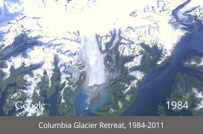
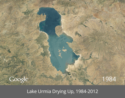
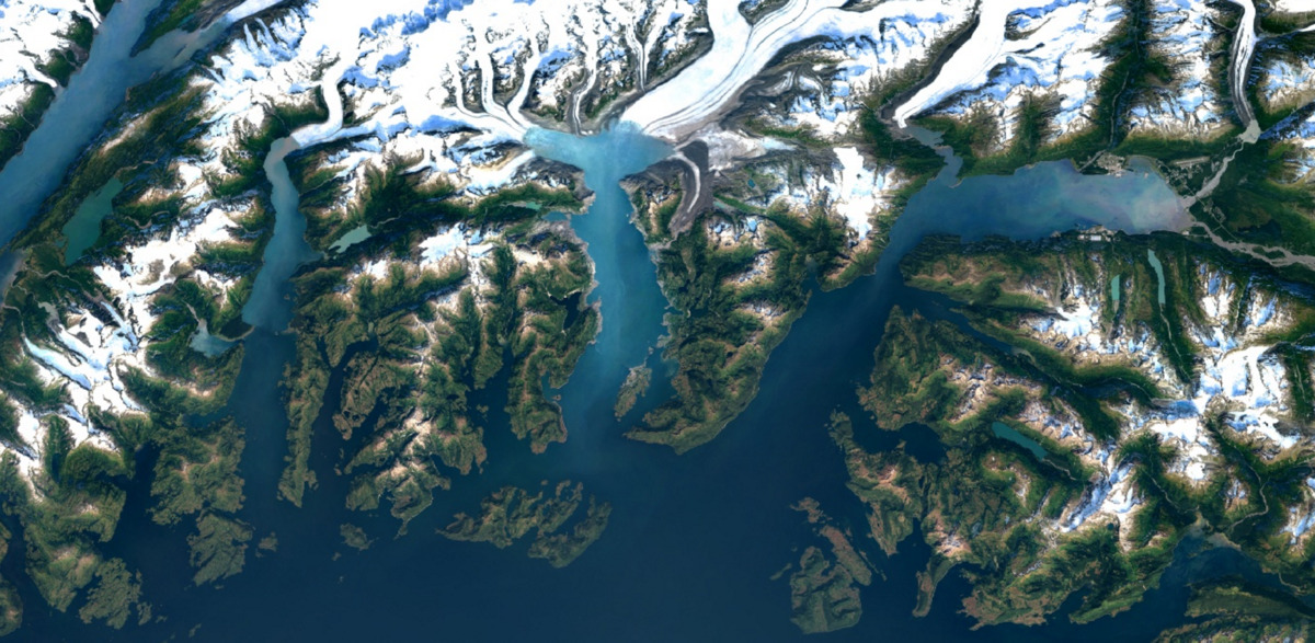
Google has provided these incredible animated GIFs illustrating the Earth’s landscape changes over the decades for Time‘s Timelapse project.
The images show deforestation in the Amazon of Brazil, glaciers retreating in Alaska, and lakes drying up in Las Vegas sprawls as well as other landscapes.
Check out more illustrations below…
Starting today, Google is rolling out its Map Maker service in the UK, allowing Google Maps users in the United Kingdom the ability to join the over 40,000 other people around the globe making contributions to improve the Google Maps experience:
Now it’s your turn to help, whether marking the trails through Brecon Beacons National Park in Wales, adding all your favorite shops in London’s Soho Square, or improving driving directions to St Ives in Cornwall. Drawing from your knowledge about world famous tourist destinations or the streets of your hometown, you can now use Google Map Maker to make the map of the United Kingdom (along with Isle of Man, Jersey and Guernsey) more comprehensive and accurate than ever before. Once approved, these improvements will appear across Google Maps, Google Earth, and Google Maps for Mobile.
Google is encouraging users in the UK to submit contributions through Map Maker and also invited them to check out its “community of mappers” and the “Map Maker Help Center” for additional information.
Google announced today on the Google Earth Google+ page that it is launching a major update to the iOS, Android, and desktop Google Earth apps. Google is updating the tour guide and 3D imagery features it launched in October with Google Earth 7, and it announced the addition of 100,000 new tours of “popular sites, cities and places across 200 countries.” It is also adding as over 1 million user-generated Panoramio photos:
The new, richer tours combine 3D flyovers, Wikipedia snippets and – for the first time – place highlight and more than 1 million user-generated Panoramio photos in order to create an immersive and educational exploration of your favorite places. Each tour ends with a selection of photo thumbnails which were selected from Panoramio as the best representation of a given place. Clicking on one of the thumbnails enables a full screen photo experience.
Expand
Expanding
Close
[tweet https://twitter.com/googlemaps/status/269499168354091008]
As noted on the Google Maps blog, Google continues to update maps with new aerial, satellite, and 45-degree imagery for many cities in the U.S. and abroad. Google’s most recent addition to maps is a new collection of 45-degree imagery for 60 new cities—40 in the U.S. and 20 internationally— in places like Switzerland and Luxembourg. That brings the total number of cities with updated aerial and satellite imagery in Maps and Google Earth up to 164 cities in 108 countries. Google walked through a few of the recent updates, such as the Space Needle in Seattle and Bridges in the Sky art installation in Austria, but also provided a full list of cities with new high resolution imagery (below):
Expand
Expanding
Close
On the Lat-Long Blog today, Google announced it is making new features available in the latest version of Google Earth including the tour guide and 3D imagery it rolled out to the mobile apps in July. Google Earth 7 for the desktop now includes “comprehensive and accurate tours of more than 11,000 popular sites around the world, including our growing list of cities where new 3D imagery is available.” Google is also rolling out more accurate 3D imagery for new areas:
In addition, Google Earth 7 now includes the comprehensive, accurate 3D imagery we’ve already made available on Android and iOS for Boulder, Boston, Charlotte, Denver, Lawrence, Long Beach, Los Angeles, Portland, San Antonio, San Diego, Santa Cruz, Seattle, Tampa, Tucson, Rome and the San Francisco Bay Area (including the Peninsula and East Bay). And today, we’re adding more 3D imagery for a handful of metropolitan regions including Avignon, France; Austin, Texas; Munich, Germany; Phoenix, Arizona; and Mannheim, Germany.
You can download Google Earth 7 here.
Expand
Expanding
Close
[youtube=http://www.youtube.com/watch?v=1bFdNFTq8Vw&feature=player_embedded]
Sustrans, a British charity promoting sustainable transport, just announced that it partnered with Google to bring cycling routes to United Kingdom-based Google Maps users.
Greener-minded Americans are quite familiar with the biking icon and its bevy of alternative transit routes, but now U.K. fans of the popular mapping app can plan their cycling trips, navigate bike lanes, and time routes on both smartphones and computers. For those unfamiliar, Google Maps offers worldwide mapping technology, directions and local business information to mobile and desktop users by way of satellite and street-level imagery and user-contributed content.
“We know how popular cycling is in London and the rest of the UK, especially ahead of a busy summer, which is why we are thrilled to bring cycling directions to Google Maps. Thanks to Sustrans, we now have thousands of miles of trails and routes, as well as bike lanes and recommended streets for cities across the country,” said Google UK Geospatial Technologist Ed Parsons.
“We’ll continue to add new trail information and urge commuters to swap their car for a bike as they can now find a convenient route that makes use of dedicated bike tracks and avoid hills whenever possible, Parsons added.
The new feature goes live today, and Sustrans is celebrating the launch with its own video, called “Lucy’s Cycling Treasure Hunt” (above).
The press release is below.